Cite this as: Roberts, L. and Hamel, A. (with contributions from A. Shaw, C. Mellett and E. McNeill) 2023 The Submerged Palaeo-Yare: a review of Pleistocene landscapes and environments in the southern North Sea, Internet Archaeology 61. https://doi.org/10.11141/ia.61.8
The offshore marine aggregate dredging industry provides around 20% of sand and gravel sales in England and 48% in Wales. The aggregate is dredged from licence areas that are grouped into a number of geographic regions around the coast of England and Wales, reflecting the discrete spatial distribution of the geological deposits that contain commercially viable resources relative to their proximity to the market – predominantly the construction sector, although some resources are used for coastal defence. In order to obtain a marine licence (regulatory permission) to dredge from the regulator (the Marine Management Organisation), marine aggregate companies commission environmental assessments that include archaeological assessments of each licence area. These archaeological assessments review existing data from the United Kingdom Hydrographic Office (UKHO) and the National Marine Heritage Record (NMHR), as well as any further research, and also assess marine geophysical and geotechnical data to identify archaeological potential. However, unexpected archaeological finds are still likely to be encountered, from previously unknown shipwreck or aircraft crash sites, or from Palaeolithic sites or as isolated artefacts, as the area, although now submerged owing to sea level rise, was once dry land suitable for occupation.
In 2003, the British Marine Aggregate Producers Association (BMAPA) and English Heritage (now Historic England) published a guidance note: Marine Aggregate Dredging and the Historic Environment: Assessing, evaluating, mitigating and monitoring the archaeological effects of marine aggregate dredging (BMAPA and English Heritage 2003). This guidance was at the forefront of identifying potential impacts on the historic environment. It covered the process of archaeological assessment in relation to environmental impact assessments and recommended mitigation, including the establishment of monitoring protocols to manage unexpected discoveries of features of archaeological interest.
To address this recommendation, BMAPA and English Heritage produced the Marine Aggregate Industry Protocol for Reporting Finds of Archaeological Interest (the 'Protocol') (2005), prepared by Wessex Archaeology, and The Crown Estate joined the scheme as a funding partner in 2009. While protocols could have been implemented individually for each licence area, the dredging industry recognised that it would be much more efficient to have a single Protocol that could be applied to all licence areas operated by BMAPA members. This would also facilitate the archaeological interpretation of discoveries across a wide geographical area, rather than looking at each find in isolation.
The Protocol advises staff on how to protect our submerged heritage. It recommends that every find of archaeological potential discovered during aggregate dredging or processing is reported through the Protocol's Implementation Service, run by Wessex Archaeology. The Implementation Service investigates every find reported with the support and advice of a wealth of specialists, both within Wessex Archaeology and externally across the country and beyond. The way finds are reported allows our submerged heritage to be understood and this information, gained thanks to the diligence of the staff of BMAPA member companies, has become an important resource for informing other offshore projects. The Protocol itself has also been successfully used as a basis for multiple other such offshore scheme protocols.
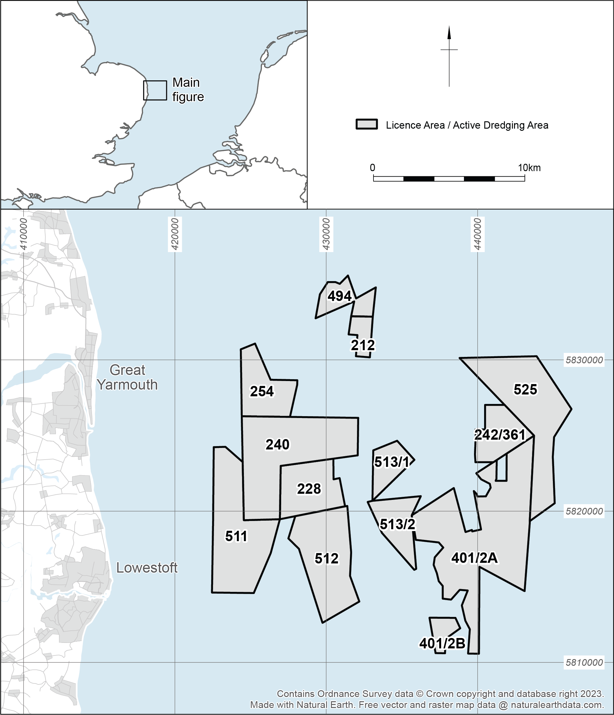
In 2007/2008, Palaeolithic flint artefacts, including handaxes, flakes and cores, as well as a series of animal bones (woolly mammoth, woolly rhino, bison, reindeer and horse) were discovered by Mr Jan Meulmeester in stockpiles of gravel at SBV Flushing Wharf in the Netherlands (Firth 2011, Tizzard et al. 2014, 2015), which had been dredged from marine aggregate Licence Area 240. Area 240 is located approximately 10km off the coast of East Anglia, near Great Yarmouth, and is part of a regional block of licence areas that have been worked since the 1970s, the 'East Coast region'. This region is associated with the ancient course of the River Yare. The finds were identified from stockpiles and reject piles. The fresh condition of some of the artefacts indicated that they came from relatively undisturbed deposits. Comparison of the dates when material was recovered along with the movements of the dredgers supplying the wharf revealed that the finds had been dredged from a small area within Area 240. In order to prevent any damage to material remaining on the seabed, the marine aggregate company, Hanson Aggregates Marine Ltd (HAML), voluntarily implemented an Archaeological Exclusion Zone (AEZ) covering the dredging lanes from which the material had originated.
Between 2008 and 2013, Wessex Archaeology undertook a series of multi-disciplinary projects to understand the palaeogeography and archaeology of the area and to improve the future management of the potential effects of aggregate dredging on the marine historic environment. Funded by English Heritage through the Aggregate Levy Sustainability Fund (ALSF), the Seabed Prehistory: Site Evaluation Techniques (Area 240) project was undertaken between 2008 and 2011 (Wessex Archaeology 2011a), and included the acquisition and interpretation of geophysical data, geotechnical data, seabed sampling, vibrocoring, palaeoenvironmental assessment, analyses and dating. This was followed in 2011 by a programme of archaeological monitoring of aggregate dredging within Area 240 and its subsequent processing in the Netherlands, commissioned by HAML (Wessex Archaeology 2011b). The project trialled methods of bulk sampling the seabed using standard aggregate dredging plant in order to recover artefacts, and evaluate the presence/absence, distribution, character, quality and preservation of Palaeolithic material in Area 240.
The work carried out in Area 240 highlighted the fact that the evaluation of the relationships between the archaeology and palaeogeography could not effectively be carried out on a licence by licence basis, and the BMAPA acknowledged that a regional approach was required (Figure 1). The Palaeo-Yare Catchment Assessment project was subsequently undertaken, aiming to map key Palaeo-Yare sediment deposits and develop hypotheses about the archaeological potential of the region in order to support decisions relating to the assessment and management of future marine aggregate operations (Wessex Archaeology 2013a, 2013b, Tizzard et al. 2014, 2015). The hypotheses were then incorporated in a Written Scheme of Investigation (WSI) for the Anglian (or East Coast) Region (Fjordr 2015, 2016). The programme of archaeological monitoring, which began in Area 240 in 2011, was expanded to assess aggregate dredged from other licence areas across the Palaeo-Yare region. Archaeologists from Wessex Archaeology visited wharves that received aggregate from licences in the East Coast Region, assessing a percentage of cargoes for archaeological remains, in order to evaluate the archaeological potential of each area. These visits were described as 'Operational Sampling'. Operational Sampling has assessed thousands of tonnes of aggregate between 2012 and 2023 and is ongoing (Wessex Archaeology 2014, 2015, 2021).
Discoveries reported through the Protocol, made during Operational Sampling, and the results of archaeological assessments of geophysical and geotechnical data (summarised in reports such as Wessex Archaeology 2014, 2015 and 2021) have all contributed considerably to our understanding of the Palaeolithic in the Palaeo-Yare and have been captured in the North Sea Prehistory Research and Management Framework (by Landward Research Ltd and Wessex Archaeology 2023).
When the BMAPA and English Heritage Protocol for the Reporting of Finds of Archaeological Interest was first developed in 2005 it was ground-breaking. It provided a way for staff in the marine aggregate industry to report unexpected finds of archaeological interest in a way that was simple and convenient. Since then, and because of its ongoing success, the Protocol model has been adapted and adopted for a wide range of industries, such as offshore renewable energy, ports and harbours, and cable routes.
Although there have been numerous changes in staff since the inception of the Protocol, at the wharves, on the vessels and within the Implementation Service, the Protocol continues to be utilised, providing an essential 'safety net' for unexpected discoveries. This is due to the robust nature of the Protocol and its well-established methodologies. Little has changed since its inception in the reporting process, the assessment of finds, or the liaison with specialists, archaeological curators, the Receiver of Wreck and aggregate companies.
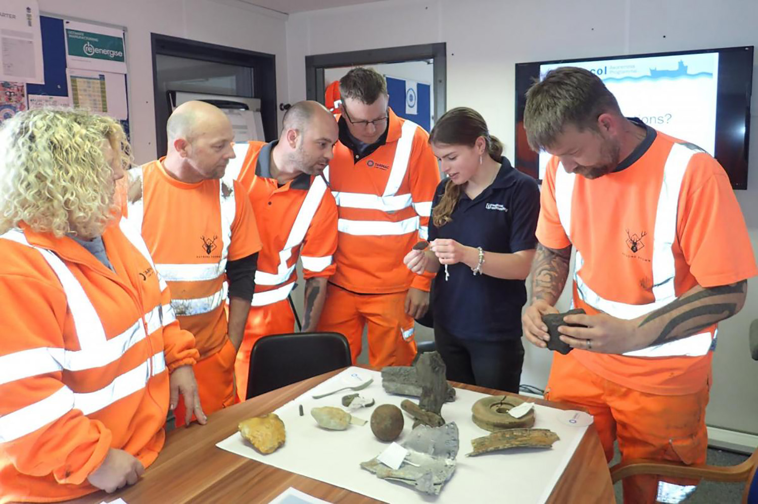
The functioning of the Protocol is supported by Awareness Visits, with members of the Implementation Service visiting staff at wharves that receive marine aggregate (Figure 2) or on dredging vessels. During the visit, wharf and vessel staff learn (or re-familiarise themselves with) the different types of material that could be of archaeological interest, including flint tools, pottery, shipwreck material and aircraft remains, and how to report it through the Protocol.
The Implementation Service, which is funded by BMAPA and The Crown Estate and supported by Historic England, keeps in touch with wharves throughout the year, and produces a bi-annual newsletter, Dredged Up (for example, Wessex Archaeology 2022) that is published every spring and autumn.
The Protocol's reporting year runs from 1 October to 30 September. An Annual Report (for example, Wessex Archaeology 2023) is produced at the end of each reporting year, summarising all of the finds that have been made during the year, looking at artefact patterns and distribution, and reflecting on the process.
All issues of Dredged Up and the Annual Reports are available online and through the Archaeology Data Service.
Since the inception of the Protocol, which is currently funded by BMAPA and The Crown Estate with support from Historic England, over 1800 finds have been reported from across the UK. These finds are assessed, and in many cases further information is requested from specialists. Reports are then produced and sent out to the wharves and vessels that reported the finds, the local Historic Environment Records (HERs), Historic England's NMHR, The Crown Estate, and the Receiver of Wreck. The records can be retrieved through Historic England, through the Annual Report (i.e. Wessex Archaeology 2023), on Facebook, and now through a Storymap. It is important to note that without the Protocol it is likely that these chance finds would have remained as small curiosities to the finders, possibly celebrated by the individuals and their colleagues who made the discovery, but certainly not becoming as accessible to the wider public as they are currently.
Operational Sampling comprises archaeologists visiting aggregate wharves receiving sediments dredged from licence areas in the Palaeo-Yare region in order to examine a sample of the aggregate for archaeological remains. The process was conceived in order to allow the development of a regional framework that would result in a better understanding of the prehistoric archaeological resource in terms of its distribution, significance and the mitigation of effects from marine aggregate dredging.
To focus the process, a provisional WSI was produced in 2012 (see Appendix A in Wessex Archaeology 2014) which proposed Operational Sampling events for archaeological assessment of aggregate at wharves, the rationale for which is discussed in more detail elsewhere (see Ward et al. 2014). It was followed by an updated WSI (Fjordr 2015). The implementation of the updated WSI, including Operational Sampling, has been a condition of each of the marine licences (issued for a 15-year term) permitted for aggregate extraction in the East Coast Region since March 2014. This regional approach recognises how archaeological questions about the distribution of early prehistoric material discovered from different extraction areas, potentially operated by different companies, can be addressed at a regional scale. This collaborative approach further builds on the way the marine aggregates' regional assessments were undertaken (Limpenny et al. 2011, EMU 2012) and how the Palaeo-Yare Catchment Assessment was developed.
For Operational Sampling to satisfy marine licence conditions, aggregate companies dredging in the East Coast Region periodically dredge a large sample of sand and gravel from known locations within each extraction area. When the aggregate is landed at the wharf, the sample is, as far as practicable, kept separate from aggregate dredged from other licence areas and is then archaeologically assessed by archaeologists visiting the wharf and examining the sediment.
The WSI sets out the common approach to the process, including the aims, objectives and methodological principles. The WSI is accompanied by:
Following the updated WSI (Fjordr 2015), an Appendix (Fjordr 2016) was produced detailing the understanding of the geoarchaeology of the Palaeo-Yare and presenting hypotheses to be tested through Operational Sampling. The hypotheses were developed to support themes, such as: inhabitation; choice and use of location; natural processes; human processes including dredging history; and operational sampling methods. One key hypothesis has been proven throughout: finds have been made at all wharves where Operational Sampling takes place (Wessex Archaeology 2021) highlighting the efficacy of the process.
There are currently 11 active licence areas in the Palaeo-Yare region (Areas 228, 240, 242/361, 254, 401/2A, 494, 511, 512, 513/1, 513/2, and 1804), covering approximately 180km². The development and implementation of Licence-Specific Method Statements (Wessex Archaeology 2016a, 2016b, 2016c, 2017) are a condition for each of the marine licences for the East Coast Region. The Licence-Specific Method Statements apply the WSI and associated Appendix (Fjordr 2015, 2016) to the specific palaeogeographic circumstances of each spatial area to which the marine licence applies.
Some of the requirements for Method Statements include determining the:
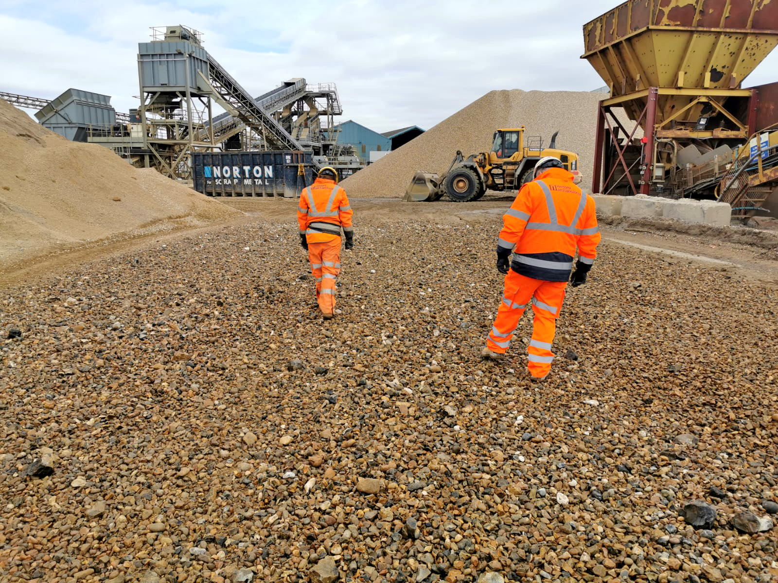
Each wharf has its own method statement depending on their facilities, and Operational Sampling has been undertaken at HAML Frindsbury (Kent), CEMEX Northfleet (Kent), HAML Dagenham (Essex) and CEMEX Dagenham (Essex) wharves. The methodologies have been tried, tested and improved over the course of numerous Operational Sampling visits. The key point is that aggregate dredged from licence areas with archaeological potential is kept separate once it is landed. Archaeologists then inspect the aggregate in a controlled way to maximise the potential for recovering finds (Figure 3).
Between 2011 and February 2023, there have been:
Following each Operational Sampling event, a summary report is produced detailing where dredging took place, the quantity of aggregate archaeologically assessed, any archaeological material that was encountered, and specialist assessments. Each of these summary reports addresses the overall hypotheses specific to each licence area. The reports are then compiled into an overarching interpretative review (e.g. Wessex Archaeology 2014, 2015, 2021), which provides details from each summary report, but also provides a wider overview and assessment. The Interpretative Report – Five Year Review (Wessex Archaeology 2021) not only tested the hypotheses, but also used evidence from the Palaeo-Yare to contribute to research questions set out in the relevant research frameworks (such as English Heritage and the Prehistoric Society 2008, Peeters et al. 2009, East Anglian Archaeology 2011, Westley and Bailey 2013).
Our understanding of the prehistoric heritage of the Palaeo-Yare area has been revolutionised by the implementation of the Protocol, the important discovery of Palaeolithic material at SBV Flushing Wharf in 2007/2008, subsequent in-depth studies of Area 240, and implementation of Operational Sampling across licence areas within the East Coast region.
The detailed studies of Area 240 have been covered in detail elsewhere (see Tizzard et al. 2014, 2015), however, this section provides a brief overview for context. The assessments of the prehistoric character of the region have revealed a complex history of deposition and erosion. Eight sediment units were identified through the archaeological assessment of geophysical and geotechnical data for Area 240, dating from the Late Pliocene/Early Pleistocene to marine deposits associated with the last transgression in the Holocene (Table 1). Each stratigraphic unit was correlated to a geological epoch or sub-epoch using British nomenclature (e.g. Devensian), which has been updated to reflect the North-West European nomenclature in order to align with the internationally recognised formal time subdivision of the Quaternary Period. These units are used to describe the geology across the Palaeo-Yare (Figure 4).
| Unit | Interpretation | Age | Description | Archaeological interest |
|---|---|---|---|---|
| 8 | Marine deposits associated with the last transgression in the Holocene | Holocene | Shelly, gravelly medium to coarse sand. | Potential to contain reworked archaeology. |
| 7 | Basal fill of a shallow under-filled channel feature (equivalent to onshore lower Breydon Formation) | Early Holocene | It comprises a basal unit of peat approximately 0.2m thick, overlain by a unit of sandy or shelly clay. Infilling of Channel B. | Highly likely to contain environmental archaeology (e.g. peat) and may preserve Mesolithic archaeology (faunal and lithic). |
| 6 | Fluvial alluvium | Possibly mid-Devensian | Sandy gravel. Only identified in Area 240. | Potential to contain Middle Palaeolithic archaeology. |
| 5 | Possibly represents an estuarine or near-coastal depositional environment | Unknown, possibly contemporary with unit 6 | Slightly gravelly, slightly silty, fine- to medium-grained sand infilling depressions. Only identified in Area 240. | Potential to contain Middle Palaeolithic archaeology. |
| 4 | Brown Bank Formation | Early Devensian (110–75 ka) | Unit 4 is a very distinctive unit generally associated with the buried channel feature in the north of Area 240 interpreted as the infilling of a cut sequence. It is comprised of fine-grained sediments (sands, silts and clays) deposited in a low-energy environment such as a river or estuary. | Potential to contain Middle Palaeolithic archaeology.
There is evidence for occupation during this period in northern France (Locht et al. 2016), and material from Dartford (Wenban-Smith et al. 2010) illustrates potential for Early Devensian occupation north of the Channel. |
| 3b | Fluvial deposits including coarser grained and finer grained sediments | 347 to 130 ka | Unit 3b is comprised of sands and gravels and forms the principal floodplain deposits of the offshore extents of the Palaeo-Yare. | Highly likely to preserve Middle Palaeolithic archaeology (faunal remains and lithics).
|
| 3a | Coarse high energy fluvial/glaciofluvial sediments | Saalian glaciation (347 to 130 ka) | A channel (Channel A) infill deposit identified in Area 240 that is associated with a channel feature probably cut into Unit 2 during the Late-Anglian glaciation. Unit 3a is the deepest, and oldest, fill primarily associated with the channel feature in the north-east and comprises gravel and sand. Only identified in Area 240. | May contain reworked Palaeolithic archaeological material. |
| 2 | Yarmouth Roads Formation | Cromerian period (478 to 787 ka) | Unit 2 generally comprises silty, gravelly, fine to coarse sands. Observed throughout the region overlying Unit 1 to the south of Area 240. To the east of the region Unit 2 is more complex and comprises silty sand with very frequent thin beds and laminae of firm to stiff clay and peaty organic clay. | Potential to preserve Lower Palaeolithic archaeology. |
| 1 | Westkapelle Ground Formation | Pliocene/Early Pleistocene | The deepest unit and is observed throughout the region. | None – pre-dates hominin occupation of northern Europe. |
Additional geoarchaeological assessments were undertaken in 2020 (Wessex Archaeology 2020a, 2020b) to review the previous geoarchaeological assessment of deposits from the submerged Palaeo-Yare. The results were compared with the existing deposit model, and where necessary the model was updated (Wessex Archaeology 2020a, 2020b, 2021).
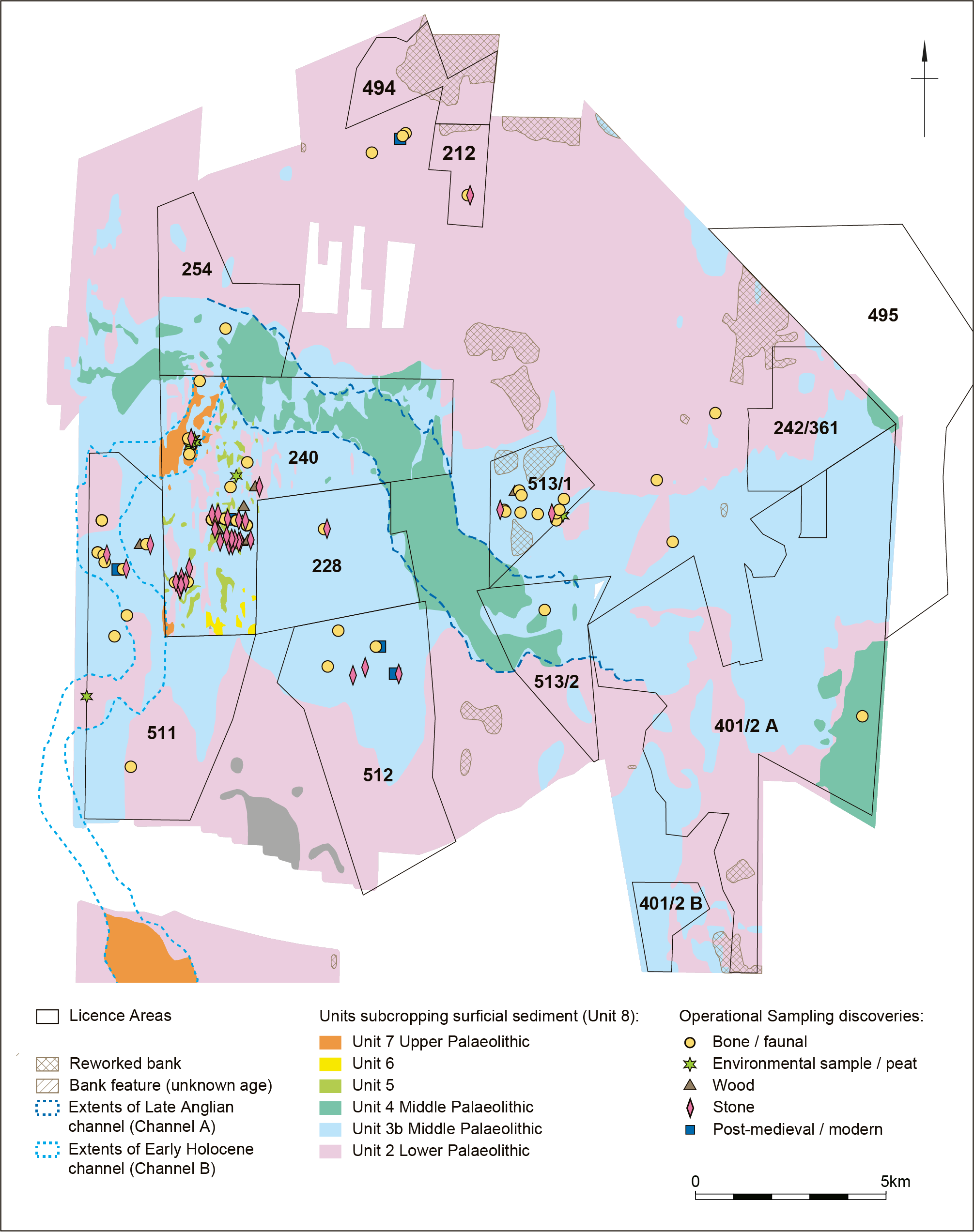
One of the biggest difficulties in assessing material recovered from the Palaeo-Yare is that none of the material can be directly associated with a single sedimentological unit reflecting a discrete period of deposition, as all discoveries are ex situ. However, based on the assessments of sedimentary units and approximate find locations, the majority of the flint artefacts recovered from Area 240 were interpreted as being principally associated with specific fluvial sediments, Unit 3b (Wessex Archaeology 2015). Deposited during MIS 7-6 (347 to 130 ka), Unit 3b forms a floodplain deposit of the middle Pleistocene channel of the Palaeo-Yare.
Operational Sampling proved that although there was a concentration of archaeological material in Area 240, there was also Palaeolithic material being recovered from aggregate dredged in other licence areas within the Palaeo-Yare region. However, the main concentration continues to be in Area 240, and since 2008, of the 88 definite flint artefacts recovered, 83 were recovered from aggregate dredged in Area 240 (Shaw et al. forthcoming).
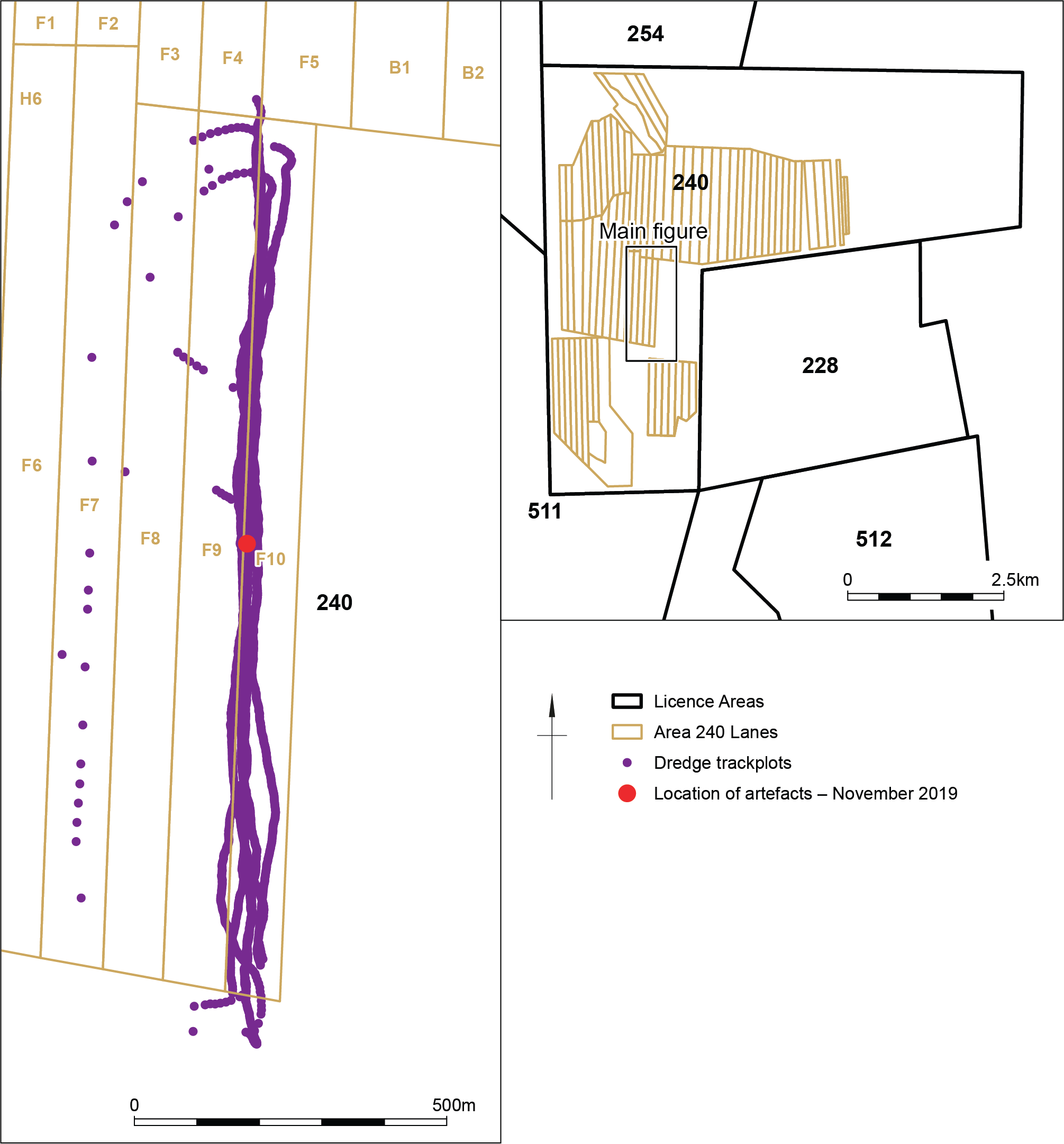
The exact provenance of each find is uncertain, as the majority of discoveries are made at the wharf rather than on board the dredging vessel, and therefore the location is generally attributed to the centre point of each vessel's dredge track; these tracks are focused on particular predefined, constrained, dredging lanes (Figure 5). Although the provenance of each find is not known precisely, the material and approximate location still provides valuable information about the use of the landscape by hominins in the past.
Hundreds of finds have been reported from the Palaeo-Yare through Operational Sampling and the Protocol. As mentioned above, one of the most significant discoveries reported through the Protocol was the initial discovery of flint tools and faunal remains identified at SBV Flushing Wharf, Holland, in 2007/2008. Since then, further discoveries have continued to broaden our understanding of the area.
In November 2019, there were further exciting discoveries from Area 240 (Wessex Archaeology 2021, Shaw et al. forthcoming). HAML staff identified a large mammoth tooth on board Arco Avon, and encouraged their colleagues at HAML Dagenham wharf to be extra vigilant for further discoveries in the cargo following its delivery. As a result, wharf staff discovered a handaxe, two worked flints and several faunal remains. The discoveries were reported through the Protocol and, owing to the completeness of the mammoth tooth and further discoveries, the cargo was flagged for further archaeological examination. An Operational Sampling visit was undertaken at HAML Dagenham wharf to investigate three cargoes of material from the same area. In total, 30 potential flint artefacts were recovered, which included five handaxes, three definite and two probable Levallois flakes, and other worked material. For faunal remains, 26 animal bones were reported through the Protocol and 85 bones were recovered during Operational Sampling. As a result, an AEZ was put around dredging lane F10 (which measures 110m wide and 1400m long, aligned parallel to the tidal axis). The AEZ means that dredging can no longer take place there. Cargoes from neighbouring lanes F8 and F9 are still observed. This discovery demonstrates how the Protocol and Operational Sampling work effectively together, to ensure significant discoveries made by wharf and vessel staff are quickly brought to the attention of archaeologists and archaeological curators, supporting discussions about the further protection of the resource and enabling decisions about future management and monitoring to be made.
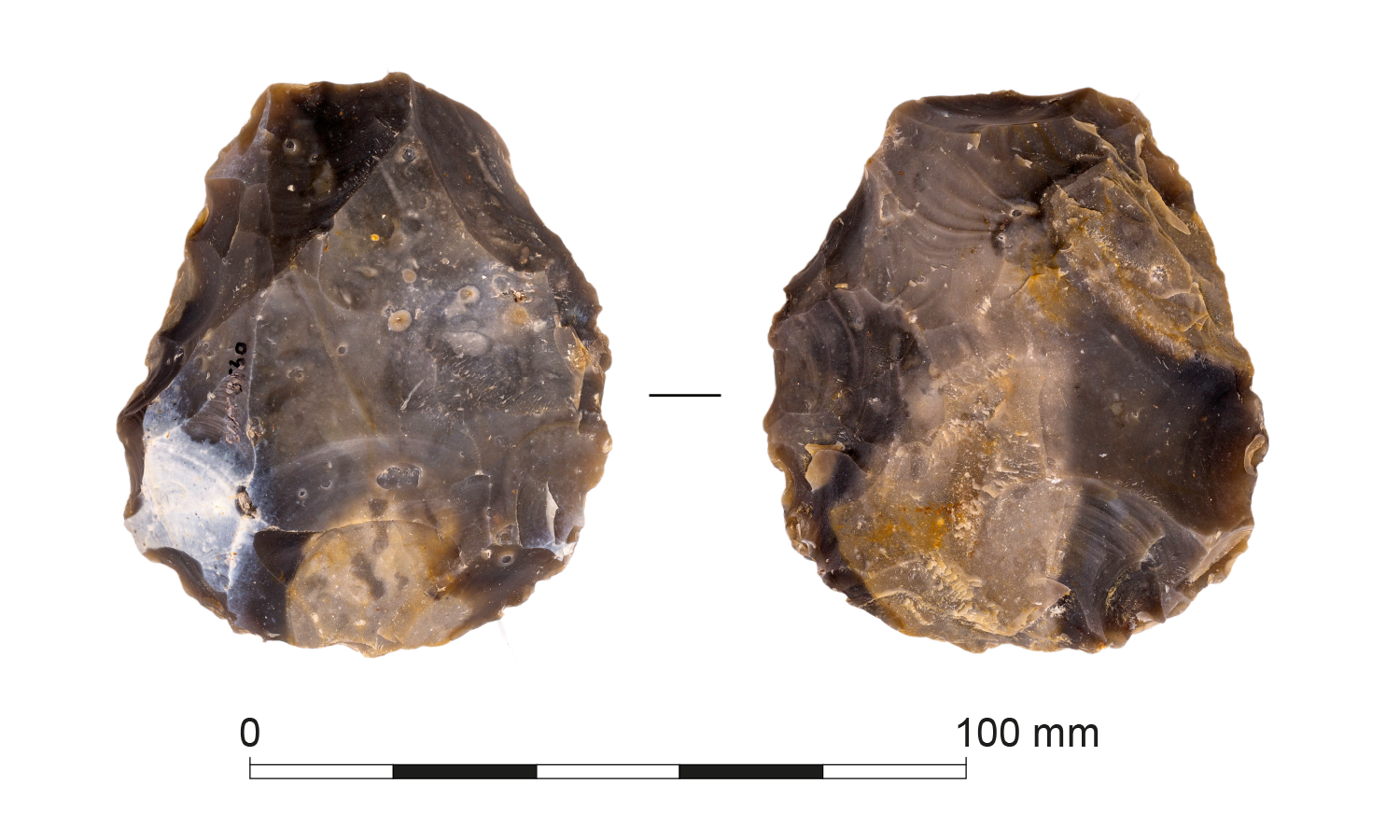
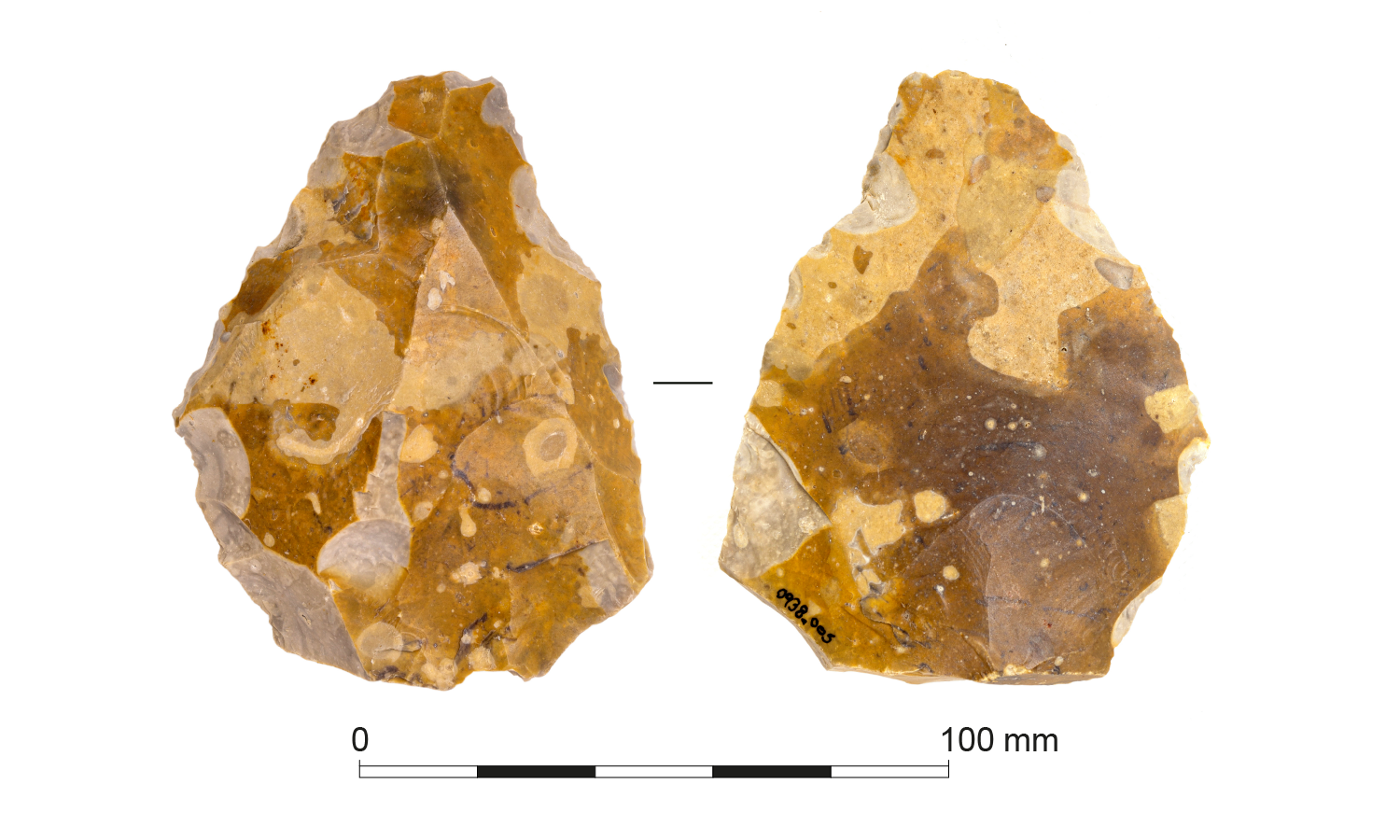
The discoveries of flint artefacts from aggregate dredged from Area 240 continue to be significant. The 2019 discoveries suggest potentially in situ material of late Middle Pleistocene age (337,000–130,000 BP). The archaeological material includes finished handaxes (Figure 6), many of which are in fresh condition, along with Levallois material, principally flakes (Figure 7), which tend to be relatively fresh but generally exhibit more post-depositional modification than the handaxes (Tizzard et al. 2015, Wessex Archaeology 2021, Shaw et al. forthcoming).
Differences in artefact condition between the assemblage types may suggest different provenances. For example, it could be attributed to the lithology of Unit 3b, which has a basal sandy unit and grades up, becoming increasingly gravelly and coarse grained (Tizzard et al. 2015). This suggests that the fresh handaxes are minimally disturbed and may originate from the basal finer sands, with some reworked into the coarser upper units, while the Levallois material likely originates from the upper, coarser sands and gravels (Tizzard et al. 2015 Wessex Archaeology 2021). Another possibility is that the Levallois material derives from Unit 3b, but the handaxes could be younger and associated with Unit 5 (Shaw et al. forthcoming).
The handaxes from Area 240 have low cortex retention and often show evidence of multiple phases of working and edge modification, which is indicative of curation and being carried around the landscape. This could suggest that a proportion of the handaxes were not produced within the area, but rather were carried in as finished artefacts, used and then discarded. However, the debitage and partially complete handaxes that have also been recovered do point to some manufacture taking place locally.
It is possible that the Levallois material was produced on gravel clasts from Unit 3b, but again these could be transported and curated objects, as there seems to be a high ratio of Levallois products in relation to non-Levallois debitage. However, the lack of evidence could be a result of the methodology of collection and aggregate sorting, where small material is pre-sorted out of the analysed sample owing to operational constraints. A more detailed study of all the Area 240 lithics has been undertaken (Shaw et al. forthcoming), which reviews all the Palaoelithic archaeology from Area 240.
The initial 2007/2008 discoveries from Area 240 comprised a large amount of lithic material recovered from a relatively tightly defined part of the area, which was thought to represent a 'hot-spot' within which evidence of Palaeolithic activity is preserved. However, the 2019 Area 240 discoveries may suggest a wider spread of 'hot-spots' or concentrations of archaeology across the Palaeo-Yare region. This possibility is also demonstrated by the hundreds of lithics and faunal remains recovered from Walcott Beach, Norfolk, following the Bacton Beach Nourishment project and believed to have derived from aggregate dredged from Licence Area 228 or 511 (Wessex Archaeology 2020c, Davis et al. 2023).
A range of faunal material has been recovered from the Palaeo-Yare region, including evidence of woolly mammoth, woolly rhinoceros, aurochs, red deer, reindeer, and horse, as well as fragmentary, mineralised or otherwise unidentifiable material. As with the flint assemblage, finds range from nearly pristine to badly degraded, suggesting very different provenances and that they derive from different sedimentary deposits. Again, the most significant discoveries have been from Area 240, and although he chronological relationships between the artefacts and fauna is currently uncertain, they suggest a location and environment in which humans and potential prey species were both present.
In 2019, a large mammoth tooth (Figure 8), one of the most complete examples recovered from the Palaeo-Yare, was discovered on board HAML dredger Arco Avon and reported through the Protocol – this is the find that prompted the Operational Sampling visit discussed above. The tooth was assessed by Professor Adrian Lister at the Natural History Museum who commented that the roots are so complete that the skull, or parts of it, are likely to still be on the seabed.
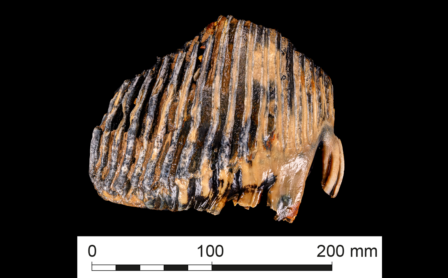
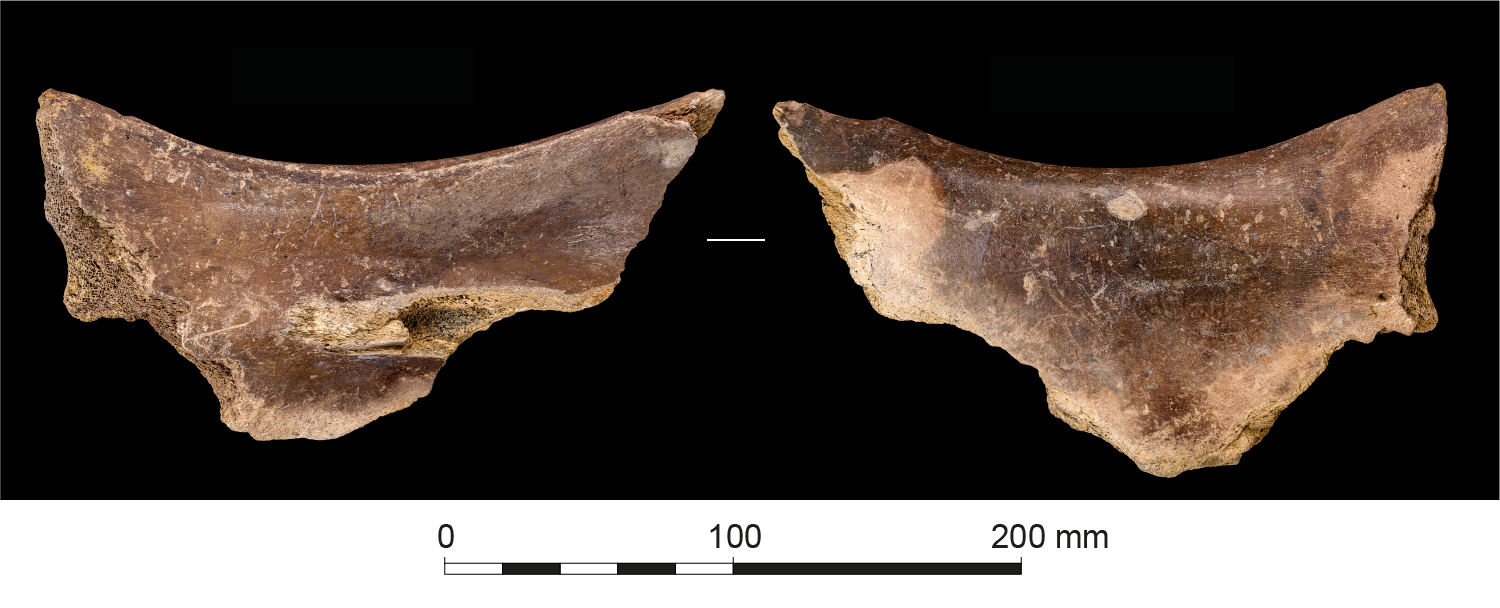
In 2020, a woolly rhinoceros' scapula (Figure 9) was discovered, in aggregate dredged from Area 240, which had unusual markings thought to be evidence of butchering. Dr Silvia Bello and Dr Simon Parfitt of the Natural History Museum examined the bone and identified the marks as hyena gnaw marks. This was the first evidence of hyena from the Palaeo-Yare, which made the discovery particularly significant. Identifying this species gives us a unique glimpse into the varied animals living in the landscape with our Palaeolithic ancestors (Wessex Archaeology 2021).
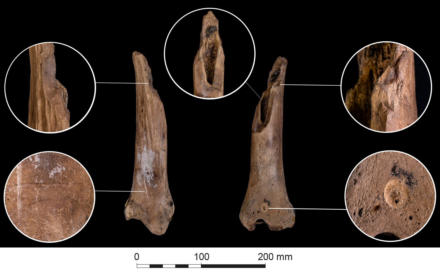
A second bone with surface modifications was recovered in May 2020. The end of a horse tibia was examined at the Natural History Museum and marks seen were also confirmed to be consistent with hyena gnawing (Figure 10). Although it is not possible to make a direct association between the horse bone and human activity in this case, it nevertheless provides useful environmental information indicating extensive grasslands (the favoured habitat of Pleistocene horses), as well as the potential for human interactions with large carnivores that were their competitors for food.
The understanding gained from discoveries that have been made during Operational Sampling and reported through the Protocol, and the results of geophysical and geoarchaeological assessments, are not limited to Area 240, but can provide context for finds 'hot-spots' in the wider Palaeo-Yare region, and to material derived from other licences such as those discovered on the beach at Walcott, Norfolk, following the Bacton Beach Nourishment Project (Wessex Archaeology 2020c, 2021, Davis et al. 2023). They can also contribute to assessments of discoveries further afield in other Palaeo river systems, such as those from the Outer Thames dredging region, recovered following the beach replenishment programme between Clacton-on-Sea and Holland-on-Sea, Essex, where Pleistocene mammalian remains and stone tools were discovered in aggregate dredged from Licence Area 447, approximately 18km east of Walton-on-the-Naze, Essex (Bynoe et al. 2022). These discoveries from offshore aggregate can contribute to our understanding of human occupation during the Palaeolithic, and need to be seen in the wider context of sites and finds across Britain and northern continental Europe.
While the vast majority of finds from the Palaeo-Yare are thought to date from the Middle Palaeolithic, there is potential for Lower Palaeolithic (970,000–300,000 BP) and some faunal remains may date to this period. Although the current evidence from the Palaeo-Yare does not contribute substantially to the understanding of this period, it does suggest hominin presence in the area and needs to be seen within the context of our current understanding of the period.
Evidence for Lower Palaeolithic occupation in the wider region comes from a relatively small number of minimally disturbed artefact occurrences such as Happisburgh 1 (Lewis et al. 2019), Barnham (Ashton et al. 1998), Elveden (Ashton et al. 2005), Beaches Pit (Preece et al. 2006), along with large amounts of material reworked to some extent within coarse river gravels (Wymer 1999). The sites at Pakefield, Suffolk, and Happisburgh, Norfolk, have provided internationally significant artefactual and palaeoenvironmental records, reflecting rare evidence for human occupation pre-dating 480,000 years ago (Parfitt et al. 2005, 2010, Lewis et al. 2019). Investigations at Happisburgh have also revealed the oldest known hominin footprint surface outside Africa at between approximately 1 million and 780,000 years ago (Ashton et al. 2014). Lower Palaeolithic lithic repertoires were generally handaxe-dominated, alongside evidence for simple core and flake working. Subsistence strategies may have included direct-hunting (Hosfield 2011), while studies of habitat preferences suggest a preference for river corridors through interglacial and more open landscapes during cooler periods (Ashton et al. 2005, 2014).
The discoveries from the Palaeo-Yare from the Middle Palaeolithic are particularly exciting, as in general, evidence for British terrestrial sites of this period is considered to be relatively scarce, particularly from the East Anglian region, compared with Thames Valley and Northern France (Ashton and Scott 2016). Therefore, finds reported through the Protocol or discovered during Operational Sampling have made a real contribution to our understanding of this period.
The boundary between the Lower Palaeolithic and the Middle Palaeolithic is signalled by changes in cultural and landscape-use practices (White et al. 2006, Scott 2011), which included a shift in lithic technology, but also other profound changes in human behaviour and in hominin adaptive, social and cognitive structures (White et al. 2006).
The Middle Palaeolithic can be divided into several phases:
Artefacts from Area 240 have been associated with the Unit 3b sediments, initially dated to MIS 9–7 (Tizzard et al. 2015). Sites in Britain and northern France dated to MIS 9 are generally handaxe dominated, but there is evidence for Levallois flaking. In contrast, assemblages dated to late MIS 8 and later are dominated by Levallois reduction strategy and handaxes are generally absent, or present in very small numbers (White et al. 2006, Scott 2011, Locht et al. 2016). Assessment of luminescence dates from Unit 3b may indicate that deposits where the Unit 3b artefacts were recovered principally date to MIS 7-6 (Marshall et al. 2020). The new dating would suggest the archaeology from Area 240 could significantly add to the evidence of occupation during this period in Britain, as current studies of model changing demographics in the region indicate greater occupation late in MIS 8 and early MIS 7 (Scott and Ashton 2011, Ashton and Scott 2016), with the possibility that late MIS 7/early MIS 6 witnessed a decline in regional population levels leading to abandonment during peak cold conditions in MIS 6 (Ashton and Lewis 2002).
Irrespective of the dating of the Unit 3b sediments, the fact that the discoveries from Area 240 include both handaxes and Levallois flakes is significant. Sites dated to MIS 7–6 in the wider region tend to lack such handaxes.
As with the Area 240 discoveries in 2007/2008 (Tizzard et al. 2015), the handaxes recovered in 2019 are in very good condition, indicating that they were recovered from a primary location, while the Levallois flakes were generally in good condition, but with higher levels of post-depositional surface modifications (Wessex Archaeology 2021, Shaw et al. forthcoming). This difference in condition suggests that the handaxes and Levallois material may come from different layers or depositional contexts, which would fit with Unit 3b comprising a complex unit and reflect multiple phase of deposition (Tizzard et al. 2015, Wessex Archaeology 2021), or could indicate that the material is from different sedimentary units, with Levallois flakes associated with the Early Middle Palaeolithic Unit 3b, and the handaxes associated with the Late Middle Palaeolithic Unit 5 (Shaw et al. forthcoming).
Interestingly, the evidence from Area 447 in the Thames region indicates a sequence dated to late MIS 7/early MIS 6 (Bynoe et al. 2022), making it broadly comparable with the Palaeo-Yare, even though the material is derived from a different river system. An assessment of the lithic assemblage that was recovered following beach replenishment indicated that the finds comprised both Levallois and non-Levallois material. In contrast to the Area 240 material, the majority of the Area 447 Levallois products were relatively fresh, with a small amount moderately abraded, while the handaxes were generally more abraded. The Levallois material and handaxes appeared to represent at least two main groupings, and their different conditions indicate that they were unlikely to be contemporary or from the same context. It has been suggested that the handaxes are Lower Palaeolithic and potentially unrelated to the early Middle Palaeolithic material.
The interpretation of the different artefact assemblages is still ongoing, and views will continue to evolve as more evidence emerges.
In Britain, the early and late Middle Palaeolithic periods are associated with different locations and occupational styles. Early Middle Palaeolithic sites are generally concentrated in the south-east of England, with a particularly strong distribution around the River Thames (Scott 2011). The sites appear to be focused on sources of flint, with suggestions of primary knapping locations or workshops, and might suggest places for reprovisioning following forays into the wider territory (Scott 2011). In contrast, evidence from the Late Middle Palaeolithic suggests a preponderance of hunting bases or camps, with exploitation of wider territories and little permanent settlement (Ashton and Scott 2016); existing sites tend to be biased towards caves, with less evidence for open-air sites.
Middle Palaeolithic sites in Britain appear to show a correlation between context and assemblage size, with large assemblages generally found adjacent to a source of raw material (for example bedrock flint sources or coarse flint gravels), whereas smaller assemblages may be found further away from raw materials (White et al. 2006, 537). The river deposits of exposed gravel bars or terraces in the Palaeo-Yare region could have provided ample raw materials, although it is also possible that the tools recovered from Area 240 were produced elsewhere and transported. It is also possible that the location provided a range of lithic, animal and plant resources in a lowland landscape (Tizzard et al. 2015).
There is not sufficient evidence at this stage to indicate whether the finds 'hot spots' in the landscape could be associated with focused activity (in the sense of being places where people were present over a definable period, or repeatedly active; see, for example, Turq 1989 Scott 2011, White et al. 2006, Shaw et al. 2016).
It is difficult to judge the extent of repeated activity at particular places. However, if the interpretation of the handaxes and Levallois products as reflecting separate phases of activity is correct (Tizzard et al. 2015 Wessex Archaeology 2021 Shaw forthcoming), it would imply that these are areas that repeatedly attracted Middle Palaeolithic groups over an extended period of time.
In contrast, the discoveries of isolated finds across the wider Palaeo-Yare landscape may indicate 'episodic sites' (Scott 2011 after Turq 1989), such as short-term hunting events, for example for red deer or reindeer.
Overall, the Middle Palaeolithic archaeology from Area 240 adds to and enhances an emerging pattern of varied but predetermined use of technology, indicating clear levels of planning and anticipated exploitation in the landscape (White et al. 2006 Scott 2011).
There is limited environmental evidence from the Palaeo-Yare, including reworked charcoal and wood from Area 254 which indicates a cold estuarine environment (Tizzard et al. 2015). The environment can be reconstructed within a framework of generalised glacial/interglacial flora development; for example, during a cooling trend leading into a glacial period, coniferous forests would likely be replaced by grassland, which in turn would develop into dry open woodland as conditions warmed leading into an interglacial (Tizzard et al. 2015). The geophysical, geotechnical and archaeological evidence from Area 240 suggests a coastal, estuarine location near the banks of a river on the margins of grassland, probably within a cool steppe landscape with some trees, with cliffs formed of Anglian till framing the coastal landscape, in a way similar to the present-day coastline (Tizzard et al. 2015).
Through an examination of the climate, it is possible to begin to speculate about possible seasonal usage of the landscape, with potential occupation when conditions allowed, noting that winter temperatures may have proved difficult and required a need for clothing and artificial shelter, although the maritime climate may have been less variable than that of sites further inland (Tizzard et al. 2015).
Very little material relating to these periods has been recovered from the Palaeo-Yare. A blade core of likely late Upper Palaeolithic or early Mesolithic date has been recovered from Area 240. The small number of finds may be due to operational methodologies, as dredging does not generally target the Unit 7 sediments associated with this period (Wessex Archaeology 2021). However, although few in number, the finds do indicate human use of the area during the Late Pleistocene and early Holocene periods.
Current understanding of the early Upper Palaeolithic settlement history of the region is based on a relatively small number of sites spread across England, Wales, northern France and Belgium. However, there is a good corpus of radiocarbon dates taken from organic material, including human remains, which indicate a series of episodic colonisation events during warmer, interstadial periods, extending from 38,500 to 29,000 BP (Jacobi and Higham 2011). There is clear evidence for Late Upper Palaeolithic activity in the region from 15,000 to 12,500 BP (Jacobi and Higham 2011). However, the extent of human occupation during the final period of intense cold that marks the end of the Pleistocene (Younger Dryas; 12,500 to 11,500 BP) is currently unclear. During the Mesolithic, temperatures rose again and the East Coast region would have been inundated as a result of sea level rise, finally becoming entirely submerged by about 7000 BP (EMU 2012).
The survival of the archaeological material is impressive and reflects the fact that now offshore zones were a key focus of human activity in the Palaeolithic and Mesolithic periods. Additionally, some of the faunal remains are in such pristine condition as to have identifiable tooth marks from predators. This suggests that damage to archaeological material from dredging activities is, in many cases, relatively minimal.
The fact that all of the material recovered to date has originated from areas being actively dredged has led to questions about how much of the archaeological resource still remains. Given that archaeological discoveries continue to be made, including the significant recovery of archaeological material from Area 240 in 2019, it is likely that a considerable quantity of material may still remain. Additionally, the recovery of important archaeological flint material from Walcott Beach following the Bacton Beach Nourishment project (Wessex Archaeology 2020c Davis et al. 2023) suggests there is potential for discovering further 'hot-spots' in the wider Palaeo-Yare region, particularly in areas that have seen minimal dredging previously.
However, there remain biases in the assemblage. Some have been mentioned above, and collection strategies during Operational Sampling may favour larger artefacts over smaller flakes (which may be excluded due to operational sorting). Other biases result from the types of material that are likely to be discovered. The evidence we have is heavily reliant on lithic artefacts and faunal remains, with limited evidence for hunting technology (as wooden projectiles and hafts would be unlikely to survive in the archaeological record).
The past use of the Palaeo-Yare landscape is coming to light through archaeological finds reported via the Protocol, from discoveries made during Operational Sampling, archaeological assessments of geophysical and geotechnical data, and research.
The most significant finds from the Palaeo-Yare continue to be the flint artefacts recovered from Area 240, which appear to reflect at least two periods of Middle Palaeolithic activity. This suggests this area, and now submerged landscapes of the Palaeo-Yare, is a key region for Middle Palaeolithic archaeology within both a British and northern European context. Other exciting finds include an almost complete mammoth tooth, as well as the rhinoceros scapula and horse tibia, which both exhibit hyena gnaw marks and provide a rare insight into species interacting in the Palaeolithic.
The evidence, however, is not just coming from the 'hot-spot' within Area 240 – there is evidence of people and animals using the landscape across numerous East Coast licence areas, and there is potential for other significant areas to be discovered in the future.
The archaeological material from Area 240 should be considered nationally significant, as it addresses two of the ten criteria established by Historic England to determine the significance of Palaeolithic sites (Historic England 2018): the remains belong to a period or geographic area where evidence of human presence is particularly rare, and artefacts are abundant.
Finds from the Palaeo-Yare continue to contribute to Historic England's goals of understanding our earliest prehistory (Historic England 2023). In particular, they can help us to understand how the landscape of Britain was shaped; what types of animals were present; how our ancestors lived; and when, where and how they fitted into those landscapes and ecosystems. Work in Area 240 and the wider Palaeo-Yare is ongoing, and future projects have the potential to continue to contribute to our understanding.
All discoveries reported through the Protocol or made during Operational Sampling visits are accessible through Storymap.
Wessex Archaeology would like to thank staff at CEMEX and HAML for facilitating Operational Sampling visits and for reporting discoveries of archaeological material through the Protocol.
We are also grateful to the specialists who undertook assessments of the archaeological material, including Dr Silvia Bello, Dr Lucile Crété, Dr Simon Parfitt, Professor Adrian Lister, Lorrain Higbee, Phil Harding, Dr Andrew Shaw and Dr Matt Leivers, and Dr Claire Mellett who undertook the archaeological assessment of geotechnical data.
Wessex Archaeology acknowledges Historic England, BMAPA and The Crown Estate for ongoing support.
Thanks also to all Wessex Archaeology staff who have worked tirelessly on Operational Sampling visits and on processing finds reporting through the Protocol.
This article was written by Lowri Roberts and Andrea Hamel, with contributions from Dr Claire Mellett and Dr Andrew Shaw. The illustrations were prepared by Kitty Foster. Victoria Lambert provided quality assurance and the project was managed by Euan McNeill.
Most of the reports on which this article is based are available through the Archaeology Data Service. However, some reports are awaiting review in the OASIS system. When these become publicly available, they will be accessible by searching for the OASIS id in the ADS library.
All finds reported through the Protocol can be viewed on Storymap: https://storymaps.arcgis.com/stories/2968f0b4062245ee815d04124bbd9368
See also Seabed Prehistory https://doi.org/10.5284/1000050 and the BMAPA Protocol for reporting finds of archaeological interest https://doi.org/10.5284/1000307.
Internet Archaeology is an open access journal based in the Department of Archaeology, University of York. Except where otherwise noted, content from this work may be used under the terms of the Creative Commons Attribution 3.0 (CC BY) Unported licence, which permits unrestricted use, distribution, and reproduction in any medium, provided that attribution to the author(s), the title of the work, the Internet Archaeology journal and the relevant URL/DOI are given.
Terms and Conditions | Legal Statements | Privacy Policy | Cookies Policy | Citing Internet Archaeology
Internet Archaeology content is preserved for the long term with the Archaeology Data Service. Help sustain and support open access publication by donating to our Open Access Archaeology Fund.
 Home
Home