1Genetic and Biometry Lab, Anthropology and Ecology Department, University of Geneva, Case Postale 511, CH-1211. Geneva 24. Switzerland. Tel: +41 22 702 69 40 Fax: +41 22 300 03 51
2Department of Earth and Environmental Sciences, Wesleyan University, Middletown, Connecticut, 06459. USA
Email: nicolas.ray@anthro.unige.ch
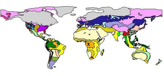
A preliminary, broad-scale vegetation map reconstruction for use by archaeologists and anthropologists is presented here for the world at the Last Glacial Maximum (18,000 BP, but broadly representing the interval from 25,000 to 15,000 BP). The global LGM map was produced from a range of literature and map sources, and drawn on a GIS with topographic information. Extended coastlines due to LGM sea-level drop were obtained using bathymetric information. The map is available in image and Geographic Information System (GIS) formats, on a global or regional basis.

Accompanying each regional map is a bibliography detailing the principal literature sources of evidence on Late Quaternary palaeovegetation and climates. The maps presented here are merely a preliminary attempt at appraisal of current knowledge and opinion, and future updated versions are intended as more information on LGM environments becomes available. Nevertheless, together with the accompanying citation summary they should provide a valuable and readily accessible source of information on current opinion in the Quaternary community. It is also hoped that the maps will themselves act as a catalyst for archaeologists to use their own data to contribute to the broader climatic/palaeovegetational picture.
Go to Table of Contents
© Internet Archaeology
URL: http://intarch.ac.uk/journal/issue11/2/index.html
Last updated: Mon Nov 19 2001