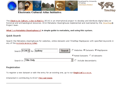
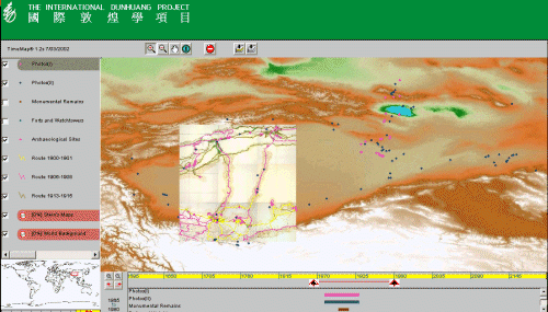
Figure 11 i & ii: Simple web-based search of the ECAI clearinghouse, and a TMJava map of data from Aurel Stein's archaeological expeditions
My final example is a cooperative international effort to make cultural data available on the Internet through a central clearinghouse and provide tools for contributing data, searching and map creation. The Electronic Cultural Atlas Initiative (ECAI) was founded in 1997, and since 1998 the TimeMap project has been developing the metadata standards, databases and software required to implement its goal of interactive map-based data sharing. The TimeMap viewers – TMView and TMJava – are both products of this collaboration.
The ECAI clearinghouse provides an open-ended body of information which can be searched for spatial datasets contributed (primarily) by ECAI Associates. The aim is to develop interoperability between the ECAI clearinghouse and other online data services, such as the UK's Archaeology Data Service, to make the ECAI clearinghouse a map gateway to other collections, and to make the material registered with ECAI available to other gateways. Searches can be carried out by spatial extent, temporal range and keywords, either through web pages or through the TimeMap Windows client, TMView. Datasets located through searches can be added to a TimeMap MapSpace which can be viewed in TMView or TMJava, or embedded as an interactive map in a web page (Figures 11i & ii).


Figure 11 i & ii: Simple web-based search of the ECAI clearinghouse, and a TMJava map of data from Aurel Stein's archaeological expeditions
Run an interactive search of the ECAI clearinghouse
This ability to search out and combine data from scattered sources leverages the value of the individual datasets and provides a tool for building composite educational map resources for online course materials. The success of this approach will be determined by the willingness of people to contribute datasets of broad use. Apart from copyright issues, there are significant issues of academic culture and reward systems which need to be addressed in order to create incentives which will help achieve a cooperative resource of this type (Johnson in press).
The use of the ECAI clearinghouse to create a digital publication series is one step aimed at creating academic incentives to contribute data. The series is hosted by the California Digital Library eScholarship web and based around maps delivered through TimeMap. The first two electronic publications in the series were completed in May 2002.
A Sasanian Seal Collection in Context
(ECAI ePublication No.1 by Guitty Azarpay and Jeanette Zerneke)
This digital publication is a report on a collection of 377 Sasanian sealstones held at the University of California Berkeley (the Edward Gans Collection). TimeMap is used to provide an interactive map illustrating the geographic context of the seals collection and of the Sasanian Empire, and the topographical relationships of a number of different types of Sasanian site (Figure 12). The map links to site records for each site and an interactive database of the seals. The map can be downloaded in its entirety together with the TimeMap Windows software (a hefty slug at 57M) or it can be accessed directly on the web as an interactive Java TimeMap.
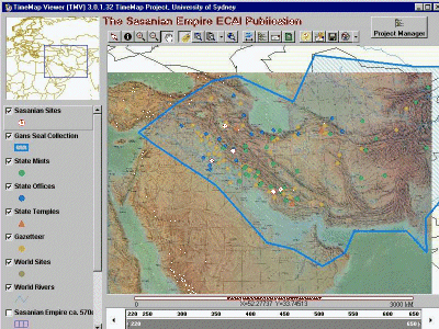
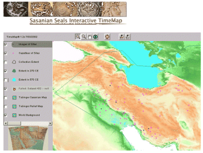
Figure 12 a & b: ECAI Sasanian Seals ePublication using TMView map viewer (top) and TMJava (bottom)
Sites and outlines link to a database-driven web site
Interactive map on the TimeMap web site (developmental)
Interactive
map on the CDL eScholarship site (archival)
Many archaeology courses, as well as public archaeology lectures, use archaeological sites, either as point sources of data or as examples to be discussed in detail. How do students locate these sites? As an undergraduate I was frustrated by the poor contextualisation of archaeological sites in published sources, typically as gross location relative to country (or even continental) outlines. This very approximate location might be supplemented with some more or less detailed local plans, dependent on the specific interests of the excavators or synthesisers. While it is not hard to chase up adequate information on one or two sites, it is a thesis job to contextualise a complete set of sites for a period or theme (e.g. King 2002). Projects such as the Perseus Digital Library provide contextualisation for particular periods or themes, but there is no single source for a broad spread of sites across the world and through different time periods.
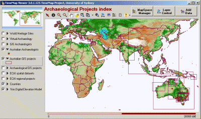
Figure 13: A worldwide index of archaeological sites and projects - select thumbnail to access TMJava interactive web map
The Archaeology Index interactive map (Figure 13) is a prototype use of the ECAI clearinghouse and a TimeMap MapSpace to map a number of web-accessible and updatable databases about archaeologists, archaeological sites and archaeological projects. We hope to extend the databases in both number and content, to make this an increasingly useful page addressed to the needs, in particular, of undergraduate archaeology courses. The databases have been seeded with information and will be extended with additional material over the coming year. By providing an example, we hope to introduce the idea of interactive web-based maps to students and staff alike. Whether the page will reach critical mass, where it becomes sufficiently useful for people to want to contribute further data, remains to be seen.
The ECAI clearinghouse and tools are still under development and testing by a small group of users, and have not yet been incorporated into teaching materials. Although access to the clearinghouse is open, it has not been widely publicised, as both the documentation and guidance on data preparation provided by the programs are as yet inadequate for casual use. We are targeting a widespread release by the end of 2002.
Last updated: Wed Sep 11 2002
© Author(s). Content published prior to 2013 is not covered by CC-BY licence and requests for reproduction should usually go to the copyright holder (in most cases, the author(s)). For citation / fair-dealing purposes, please attribute the author(s), the title of the work, the Internet Archaeology journal and the relevant URL/DOI.