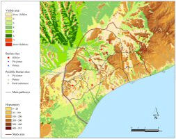
Figure 15: Cumulative viewshed from the set of hillforts of the study area
The cumulative viewshed can be defined quite simply as a sum of individual binary viewsheds. The cells of these individual maps contain values of 0 when they are not visible and 1 to indicate visibility. Thus, when they are added together the resultant raster indicates the number of times that a cell is seen from the viewer points (Wheatley and Gillings 2002, 206-7).
Archaeological research has made use of this technique in situations where patterns of visibility within a group of sites are of interest (e.g. Wheatley 1995; García Sanjuán et al. 2006). In this study, a cumulative viewshed from the set of hillforts of the study area has been generated (Figure 15).
The cumulative viewshed from all the hillforts is a raster with values from 0 (i.e. no visibility) to 8 (i.e. visibility from all the hillforts). It is, therefore, a crucial heuristic method for exploring such topics such as whether each hillfort was visually controlling an exclusive area of the landscape or if relevant areas of the territory were controlled by several hillforts. This viewshed has been carried out by summing the most probable viewsheds for each hillfort previously reclassified into a boolean set (i.e. 0 = non-visible and 1 = visible).
© Internet Archaeology/Author(s) URL: http://intarch.ac.uk/journal/issue23/4/3.4.html
Last updated: Tues Mar 04 2008