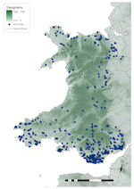
Figure 34: Distribution of finds in Wales against topographic base map

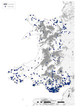
Figure 35: Distribution of finds in Wales against constraints base map

Figure 34: Distribution of finds in Wales against topographic base map

Figure 35: Distribution of finds in Wales against constraints base map
Topographically, Wales is within the highland zone. The majority of land is above 150m OD, and a band running the length of Wales, from Snowdonia to the Black Mountains, is above 300m OD (Fig. 34). This produces a natural limit on settlement, and urban development areas are restricted mostly to coastal areas, although fingers of urbanism stretch into the valleys of south Wales north of Cardiff (Fig. 35). In the west of Wales this coastal band barely encroaches inland at all. There are three areas of extensive woodland, the Afan Forest Park to the east of Swansea, and the Gwydyr and Coed y Brenin Forest Parks in Snowdonia. Several major river valleys drain from mid-Wales to the coast (e.g. the Clwyd in the north, the Tywi on the south-west and the Taff and Usk in the south), or into the Severn/Bristol Channel.
A total of 3586 finds have been reported in Wales, accounting for just 2.9% of the national assemblage (Fig. 7). A breakdown of the assemblage by period (Fig. 36) shows that, unlike any other region, it is dominated by prehistoric material, accounting for 61.6% (2206 records) of all records. Of these, 1462 records are Mesolithic finds made during field-walking. Roman material accounts for 14.6% (523 records), Late and Post-medieval 20.6% (740 records), Early Medieval just 0.5% (17 records), modern and foreign material 0.1% (4 records) and undated material 2.7% (96 records).
The distribution of finds in Wales is highly constrained (Fig. 34). The central, highland regions have produced very few artefacts and those found are generally from river valleys. A small number of coastal finds in mid-Wales are known. There is also a string of finds running from Anglesey along the northern coast, and also along the Clwyd valley. The majority of Welsh finds come from the lowland areas of South Wales, generally below 100m OD. The kernel density plot illustrates that there are just a few areas with a high density of material (Fig. 5). Concentrations are visible between Cardiff and Bridgend; along the Severn estuary north of the Bristol Channel; and a large number of finds have been made over a small area on the Gower. For most areas there is little correlation with the Roman road network, but once inland this does become a major factor, with most finds in central and southern Wales in close vicinity. Further north this is not the case, but all finds are close by modern roads.
The potential constraints on the data (Fig. 35) make a visible impact, with few finds in these areas. A total of 176 finds (4.9%) were made within areas where constraints on recovery were calculated (Fig. 37), most in urban areas (99 records, 2.8%) or above 300m OD (65 records, 1.8%), although the vast majority of the latter were made during field-walking. As elsewhere (e.g. West Central England), there is clustering of finds around urban areas, especially in South Wales.
Patterns of recovery in Wales are at odds with the English data. This is because of the massive quantities of early prehistoric worked stone found during field-walking surveys, the majority being of Mesolithic date. The bias towards this material is such that by 2005-6, 99.2% of material reported to the PAS in Wales was worked stone (Portable Antiquities Scheme 2007, 116). If this material is ignored, the patterns of recovery are within the expected range, albeit at a far lower level. The almost complete lack of Early Medieval finds, just 17 records, hinders any interpretation of the period and, as such, use of Welsh material in Section 3 will be limited.
© Internet Archaeology/Author(s)
URL: http://intarch.ac.uk/journal/issue25/2/2.4.2.7.html
Last updated: Tues Apr 21 2009