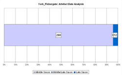
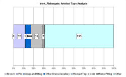
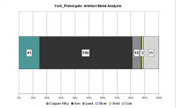
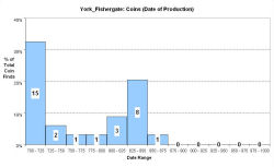
Fingerprint charts for i) artefact date analysis, ii) artefact type analysis, iii) artefact metal analysis and iv) coins – date of production


References: Kemp 1996; O'Connor 1991; Pirie 1986;
Pirie 2000; Rogers 1993
Archives:
http://ads.ahds.ac.uk/catalogue/search/fr.cfm?rcn=EHNMR-659071
46-54 Fishergate is located c. 600m south-east of the walled Roman legionary fortress on the eastern bank of the Foss, at its confluence with the River Ouse. Excavations during 1985-86 covered 2500m², primarily to investigate remains of the medieval priory of St Andrew (Kemp 1996, 5-7). The excavations also uncovered the most extensive Middle Saxon deposits found in York.
Three phases were determined, dating to the late 7th to mid-9th centuries. Period 3a was a phase of intensive occupation. Features included a slightly curved ditch, running north-south (possibly a boundary), a number of structures, and a large number of pits. Period 3a deposits were sealed by the animal bone and charcoal layer that comprised Period 3b, and is interpreted as a product of deliberate dumping. The final Middle Saxon Phase, Period 3c, comprised a number of features (including pits and another possible boundary ditch, but no buildings) that cut 3b.
The pottery assemblage is one of the largest excavated in Northumbria, and provides evidence of long-distance contacts with northern France, the Rhineland, and other regions of Britain, including East Anglia and Lincolnshire. International connections were mostly confined to Period 3a, indicating that Period 3c represented a contracted level of activity.
O'Connor's (1991) analysis of the bone assemblage has concluded that the settlement had limited access to livestock and had its meat supply provisioned in a similar manner to emporia such as Hamwic and Ipswich. The general conclusion was that Fishergate may have been part of an emporium. However, it was not as densely occupied as other wic sites and its interpretation is still open to debate. Hall (2004, 490) has suggested that a market economy was developing in York from the 8th century and that the timber halls excavated at Fishergate may have functioned as independent units, not controlled directly by the king or archbishop. Instead they may have been manufacturing and commercial depots, where surplus from rural estates was made into saleable items.
The VASLE dataset was sourced from Rogers 1993, the EMC and John Naylor.
Fingerprint charts for i) artefact date analysis, ii) artefact type analysis, iii) artefact metal analysis and iv) coins – date of production


© Internet Archaeology/Author(s)
URL: http://intarch.ac.uk/journal/issue25/2/4.4.69.html
Last updated: Tues Apr 21 2009