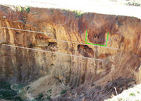
Figure 4: Many prehistoric shafts have been 'discovered' by the present quarrying, clearly showing the internal structure of these subterranean galleries (February 2003).
A first phase of aerial photography was carried out in 2003 (Fig. 2a and b), and it would be advantageous to complete this programme, at different times during the year, in order to identify new shafts. A geophysical survey of the mineral deposit would give us detailed information about the distribution of any remaining mining-related structures. A similar survey has been done for an archaeological site at La Mesa (Chiclana de la Frontera), in the Cadiz province. Such a survey would help determine the extent of the zone requiring protectection, and evaluate its environmental importance.
Lithic materials characterisation studies by the Cadiz Provincial Museum used the visual and stereomicroscopic recognition technique (Domínguez-Bella 2003, 280-5). In a later phase, a more complex archaeometrical study will be used, which may include geochemical analyses of the different samples of siliceous minerals and rocks; the preparation of thin-sections for microscopic study; scanning electron microscopy (SEM) to study the use wear; X-ray diffraction (XRD) to determine the mineral phases in the rocks, ceramics and ares; and X-ray fluorescence (XRF) spectrometry to determine the chemical properties of the materials.
A comparative study of the lithic industries and of the geological materials present in the adjacent archaeological deposits has begun in order to discover the approximate source areas of the different lithic raw materials utilised in prehistoric times. (Domínguez-Bella and Morata-Cépedes 1995; Domínguez-Bella et al. 2002). This will help determine the extent to which, within the study area, the stone implements have an autochthonous or allochthonous origin.
One of the groups of stone implements of particular interest, in relation to the mining activity, is the grooved hammer. This tool type has been recovered in different excavations, for example in the shaft areas in Zone 1 and Zone 2 of the El Jadramil site. These implements are generally made from dolerite.
Small outcrops of dolerite (named locally as ofites), occur in the vicinity of the prehistoric mining field; they are most often associated with rocks of a Triassic age, and exhibit good mechanical properties and suitable hardness for implement manufacture, especially when ground and polished (Domínguez-Bella et al. 2002; Pérez Rodríguez 1997).
Another task was to identify exactly what raw material was being mined. There are only a few examples of prehistoric mining using shafts and galleries in the Iberian Peninsula, and these were mainly associated with mining flint and copper (Domínguez-Bella et al. 2000).
A multitude of vertical shafts appear in the area around the Haza del Palmar farmhouse, shown on Figure 2b; also 'discovered' by the present quarry activity (Fig. 4).
The shafts, which have been excavated in rock (Figs 5a, b and c), are generally of circular or quadrangular section, rounded at the base, around one metre in diameter, and with variable depths of at least 6-8 metres (Fig. 5c). This excavated area (1992 survey) appeared to be covered by a thin soil layer between 0.2-0.5m thick on average, and generally reddish-brown in colour (Fig. 4).

Figure 4: Many prehistoric shafts have been 'discovered' by the present quarrying, clearly showing the internal structure of these subterranean galleries (February 2003).
In 2003, some structures similar to those reported in the present study, had been recorded, but they have subsequently been destroyed by quarrying activity (Figs 2, 3, 4 and 5).
The area, where shafts remain (black square in Fig. 2b), is of at least 5000m². However, other shafts may exist within an area of approximately 12000m². Inside these shafts, at different levels, are radial galleries where clear evidence of mining can be found (Figs 4 and 5d).
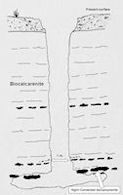
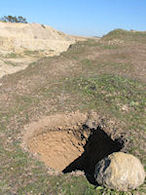
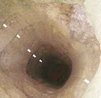
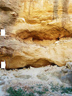
Figure 5a: Diagram of a shaft with horizontal galleries that follow the raw material nodules in order to exploit them
Figure 5b: Mouth of one of the vertical shafts, emptied by the present quarrying activity
Figure 5c: Sub-quadrangular shaft excavated in the 1992-93 rescue survey, showing the original different levels of the horizontal work, made by picking during their construction
Figure 5d: The modern quarry in 2003 that cut two levels of galleries and many vertical shafts in Zone 2 of the Jadramil site, viewed from the front.
The existence of these galleries, some of which link directly to shafts, was confirmed in the survey of 1992-1993 (Lazarich 2003, chapter 5, fig. 11).
The technology of extraction associated with these mining activities is fairly typical of other famous underground mining sites in Europe, such as Spiennes, Petit Spiennes and Rickhold. The mining tools used in El Jadramil are very similar to the ones used in the prehistoric copper mines in the west and south-west of the Iberian Peninsula (Domínguez-Bella et al. 2000). In both cases the basic tool used is a grooved hammer (Fig. 6).
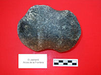
Figure 6: Figure 6: Grooved mining hammers made of dolerite were recovered in the rescue survey of El Jadramil (Zones 1 and 2).
The presence of clear marks on the walls and roofs of the galleries (Figs 5d and 7) and on the walls of all the shafts (Fig. 5c), suggest that they have been excavated using sharp tools such as chisels made of stone, bone or antler. However, as yet, there is insufficient evidence to be sure what materials were used because no mining tools have been recovered or described in previous excavations.
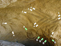
Figure 7: Marks in walls and roofs of a gallery (Zone 2) probably produced by sharper tools, such as chisels made of stone, bone or antler (marks A) and by grooved hammers (mark B). The circle shows an elliptical nodule of a more cemented stone rounded by hammer impacts during the extraction process.
© Internet Archaeology/Author(s) URL: http://intarch.ac.uk/journal/issue26/10/4.html
Last updated: Wed Jun 10 2009