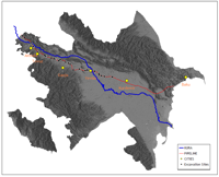
Azerbaijan relief with BTC and SCP pipeline route
The BTC pipeline route broadly passes along a syncline between the two major lines of the Caucasus Mountains: the Big Caucasus to the north and the Small Caucasus to the south, which forms the valley plain of the River Kura as it flows to the Caspian Sea. The two mountain ranges are widely separated at the coast but they become progressively closer towards the west. The route can be simplistically described as one where the first 200km run through a broad, level plain crossed by relatively few rivers, all of which drain towards the River Kura, 20 to 30km to the south. The land use is mainly over-wintering sheep pasture and limited areas of arable farming.
From the crossing of the River Kura at Yevlax (Kp200) to the second crossing of the Kura (Kp411), the pipeline passes through a more varied broken landscape with the Kura some 10 to 15km to the north. The plains are dissected by a series of rivers that drain from the Small Caucasus northwards to the Kura. A variety of crops are grown where conditions allow, but in general, irrigation is required for the bulk of arable crops.
Beyond the second Kura crossing (Kp411) to the Georgian border (Kp440), the pipeline runs along the north side of the Kura valley floor, skirting the foothills of the Caucasus.
Nearly the whole of the lowland surface of the pipeline route is marked by evidence of recent agricultural practice. In many cases, this results from use of land during Soviet times. In many areas, arable farming is governed by a practice where land is left fallow for about five years followed by intense use for several years. This process is controlled in the main, by the availability of irrigation water, which often means that whole blocks of land appear to be abandoned and derelict for several years.
In the more upland, slightly hilly areas, which have never been ploughed, the landscape is generally covered by signs of over-wintering locations for sheep and goats. These are usually seen in the form of pit-houses - rectangular, semi-subterranean structures that housed people or stock. Examples can be viewed on Google Earth at 40°04'00.25"N 48°55'10.83"E (requires plugin) and were the primary element of features identified by Rog Palmer, in his aerial photography study [PDF] (Palmer and Zuk 2002).
During excavations on the pipeline route, several examples of such pit-houses were identified at Girag Kasaman II, Asrikchai and Lak II. These were of Antique and Iron Age date. It is possible to see such structures still in use today, but it is likely that many of the visible surface features date to the past 100 years. This type of feature has been in common usage throughout time in the entire region, but it is likely that prior to the adoption of mechanical ploughing on an industrial scale, many such features would have been found over the entire landscape of lowland Azerbaijan.
© Internet Archaeology/Author(s)
University of York legal statements | Terms and Conditions
| File last updated: Fri Jun 17 2011