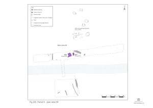
Although there is no sign of latest Roman activity within the Northern hinterland nominally east of Road 1, two immediately adjacent Early Saxon structures, almost certainly a pair of contemporary sunken-featured buildings, occupy the north bank of the largely defunct river channel (where investigated within Excavation Area R) (Figure 220). There are no pits or other remains in association, though it is likely that wood-lined ditch/channel 25271 continues to function, or is at least still visible into the 5th century.
This lack of activity may primarily be a product of this vicinity's marginal location between the upper terrace edge and boggy watercourse. The Crescent Road excavations (Drury and Wickenden 1982; Wickenden 1986) attest the concerted presence of Early Saxon settlement only a short distance to the north, on slightly higher ground.


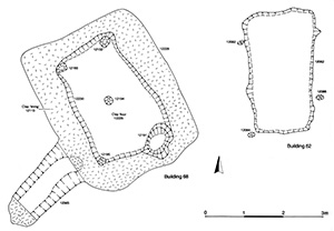
Building 67 comprises shallow rectangular cut 12062 which measures 3.2m by 1.7m and only 0.12m deep (Figure 221). It is surrounded by at least three stake-holes (12082, 12084, 12086 and one additional north-eastern stake-hole that almost certainly merges into the outline of the main cut). This sunken-featured building has clearly suffered machine truncation during topsoil stripping, but is well defined against the homogeneous silty gravel deposits of Period 4.
The fills of this feature contain few finds, with just 400g of tile and forty-two sherds of pottery. Residual Roman material is oddly scarce, perhaps because earlier artefacts are well buried below the Period 4 consolidation layers of the north bank.
Building 68 is principally defined by vertical-sided rectangular cut 12228, measuring 4.2m by 3.4m and 0.9m deep (Figure 221). It contains a substantial clay lining that extends up ramp-like extension 12365, located in the south-west corner. Inside this thick clay lining is smaller, centrally located, rectangular cut/void 12230, measuring 3.4 by 2m. At just under 0.9m deep, it does not penetrate through the base of the clay lining. Single small post-holes 12192, 12193 and 12194 are located at three of the corners of 12330 and another, 12195, at its centre. A fourth post-hole may originally exist at the south-east corner, but will have been removed by much larger, 0.8m-wide, post-hole 12364.
The base of cut/void 12230 is distinguished from the clay lining by being a compacted and dirty clay deposit of only a few centimetres thickness. This is overlain by another thin (0.03m thick) mixed clay layer. These may simply be the contaminated interface with clay lining 12228, but could perhaps be floor layers. The remainder of the cut/void is infilled with dark brown silts to a depth of 0.2m, which constitute later infilling of the abandoned building.
It is most likely that Building 68 is a second sunken-featured building of Early Saxon date, although alternatively the clay lining may indicate that it is some sort of tank, perhaps with a protective roof structure, and is associated with the later use of nearby wood-lined ditch 25271 (Group 969 Period 4).
Internet Archaeology is an open access journal based in the Department of Archaeology, University of York. Except where otherwise noted, content from this work may be used under the terms of the Creative Commons Attribution 3.0 (CC BY) Unported licence, which permits unrestricted use, distribution, and reproduction in any medium, provided that attribution to the author(s), the title of the work, the Internet Archaeology journal and the relevant URL/DOI are given.
Terms and Conditions | Legal Statements | Privacy Policy | Cookies Policy | Citing Internet Archaeology
Internet Archaeology content is preserved for the long term with the Archaeology Data Service. Help sustain and support open access publication by donating to our Open Access Archaeology Fund.