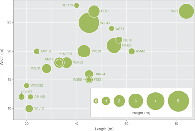

A key element of how long barrows visually influenced the landscape is their size, and this should not be neglected, despite the narrative appeal of considerations of materiality, pre-mound structures and transformations. WS71 and WS86 are approximately in the middle of the size range of long barrows in the SWHS and environs (Figure 12). A few patterns immediately emerge from this data. Firstly, WS1 is exceptional in terms of its length, being more than 20m longer than the next longest barrow in the WHS and environs, although still some distance shorter than Tilshead Old Ditch long barrow to the north in the Salisbury Plain Training Area (SPTA) (McOmish et al. 2002). Secondly, a group of barrows (AM7, AM140, WOO2, WIL13) form a small cluster at the low end of the size range, suggesting that they may represent the sub-group of oval barrows identified by various scholars, and suggested by some to be of later date (Harding and Gingell 1986), although only AM7 has the near-continuous ditch generally used to classify this form of barrow. Work beyond Wiltshire has suggested that the category of oval barrows is more complex, with burials from oval barrows at Whiteleaf, Bucks, and Mount Farm, Oxfordshire, dated to the Early Neolithic (c. 3700–3400 cal BC) but construction and remodelling of these monuments continuing well into the Middle Neolithic. Of the possible oval barrows from the SWHS and environs only WOO2 has produced dating evidence, in the form of Early Neolithic pottery from features beneath the barrow mound, and within the barrow ditches. While this could be related to pre-barrow activity long before the construction of the earthen mound, and residual material remaining on site, with no contradictory dating evidence, this argument appears to be special pleading. As such, the oval barrows in the WHS and environs cannot be said to support the hypothesis that their morphology corresponds with a later date.
Most long barrows in the SPTA are noted as having a greater height/width at their eastern ends, suggesting both that this was the main focus of activity and this cardinal solar direction was significant to the builders (McOmish et al. 2002, 21). Likewise, a survey of the unexcavated DUR24 identified a rectangular 'tump' at the south-eastern end (NMR number: SU 14 SW 23). Excavations conducted by Hoare and Cunnington at WIN53 found a primary cremation covered by a flint cairn at the eastern end of the mound (Hoare 1812) and similarly Hoare revealed four primary inhumations on the floor at the eastern end of the WIL30 long barrow mound (Hoare 1812). Thurnam's work at WS1 discovered human remains at the north-eastern end (Thurnam 1865, 143, cited by Bowden et al. 2015, 17), while his work at AM14 found three primary burials at the south-eastern end of the barrow (Grinsell 1957, 137). Recent work at WS71 shows that the barrow ditches appear to be larger and better defined at the north-eastern end and shallower and segmented towards the south-western end. It is probable that the mound at the eastern end was larger as a result of the greater quantity of material extracted from the ditches.
Internet Archaeology is an open access journal based in the Department of Archaeology, University of York. Except where otherwise noted, content from this work may be used under the terms of the Creative Commons Attribution 3.0 (CC BY) Unported licence, which permits unrestricted use, distribution, and reproduction in any medium, provided that attribution to the author(s), the title of the work, the Internet Archaeology journal and the relevant URL/DOI are given.
Terms and Conditions | Legal Statements | Privacy Policy | Cookies Policy | Citing Internet Archaeology
Internet Archaeology content is preserved for the long term with the Archaeology Data Service. Help sustain and support open access publication by donating to our Open Access Archaeology Fund.