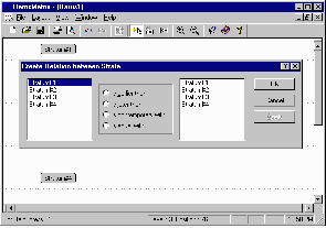

Figure 1 (left): Creating relationships between strata in ArchEd.
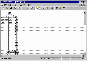
Figure 2 (right): Zooming out of the final matrix.
York Archaeological Trust, Cromwell House, 13 Ogleforth, YORK. YO1 7FG. Tel: 01904 663043. Fax: 01904 663024. Email: mrains@yorkarchaeology.co.uk
Cite this as: Rains, M. 2000 Review of ArchEd and Stratigraph - Excavation recording and analysis software[Software], Internet Archaeology 8. https://doi.org/10.11141/ia.8.9
This review investigates two software packages, ArchEd and Stratigraph, which have been developed to assist with the recording and analysis of archaeological excavations. Both provide facilities for the automatic production of Harris matrix style diagrams from stratigraphic relationships. ArchEd limits itself to this single function. Stratigraph, on the other hand, attempts to take things further by incoporating its matrix-drawing capabilities into a full excavation recording database.
ArchEd, from the Max Planck Institut für Informatik at Saarbrücken in Germany (Available at: http://www.mpi-sb.mpg.de/~arche/), has been developed for Windows 95/98/NT from the earlier DOS-based Bonn Seriation program developed at the Amt für Bodendenkmalpflege in Bonn in 1990.
The package (version 1.0) is available for free download from http://www.mpi-sb.mpg.de/~arche/StartPage.html in the form of a 1.1mb self-extracting archive. The user guide (in MS Word format) is available as another 290KB download. Installation, which follows normal Windows conventions, is fast and trouble free.
Basically, ArchEd takes stratigraphic relationships entered by the user and produces a well-formatted Harris matrix diagram. This is all it does. It doesn't have any aspirations to be an all-encompassing archaeological recording system, but what it does, it appears to do well. Contexts, which can be given automatic sequential numbers, are entered into the diagram by simple mouse clicks. Stratigraphic relationships, however, and here comes my first criticism, can only be entered either via a rather laborious dialogue box, or by a sequence of menu choices (figure 1). It might have been better if simple over/under relationships could be entered 'interactively' with a click and drag of a mouse.


Figure 1 (left): Creating relationships between strata in ArchEd.
Figure 2 (right): Zooming out of the final matrix.
ArchEd actually supports four types of relationship: earlier, later, contemporary and equal (parts of the Help system only refer to the first three). Earlier and Later are, of course, simple opposites of each other. Contemporary relationships are implemented through automatically- numbered time horizons. The effect is that contexts marked as Contemporary appear at the same vertical position in the matrix diagram. Setting an Equals relationship between two contexts effectively joins them into a single context in the diagram.
Completed matrix diagrams can be zoomed and panned (figure 2), and display options including font and colour can be set. The printing facility includes a useful print preview. Matrix diagrams can be saved to disk in ArchEd's own internal format, or can be exported to ASCII text files, Windows metafiles (both standard and enhanced), or 24 bit bitmaps.
In fact one of the most useful features of ArchEd is its ability to import and export data as ASCII files in the format generated by the Bonn program. This should allow the program to be integrated with a wide range of other systems. It took less than half an hour to write a small routine to export stratigraphic data from the YAT excavation recording system to a text file which could then be read by ArchEd.
In terms of capacity, ArchEd coped well with relatively small data sets of approximately 100 contexts and 150 stratigraphic relationships. However when given a larger data set of nearly 1000 contexts, the program did experience quite serious display problems and, in a couple of instances, crashed. This was on a system with 64MB of memory - perhaps more memory may be the solution.
In conclusion, apart from the reservations regarding the entering of relationships and the overall capacity of the system, ArchEd works very well. Its ability to import and export easily accessible data sets will be a major plus for those interested in adding an "off the shelf" matrix drawing tool to an existing excavation recording system. The system produces diagrams that are attractive on screen or on paper, and the ability to export them in 'metafile' and 'bitmap' formats makes them easy to incoporate into documents in all common word-processing and desktop publishing systems.
Since this review was first drafted, it has been suggested that the future of ArchEd might be in some doubt due to the break up of the development team at the Max Planck Institut. It is possible that further development may cease, or that ArchEd may reappear as commercial software. But, as long as ArchEd remains free of charge, it should still be considered an essential download for all field archaeologists. And even at a modest cost, ArchEd would still provide a useful addition to any software toolbox.
StratiGraf 1.1 for Windows. Platforms: Windows NT, Windows 95, Windows 98. Available in English, Spanish and Catalan. Technical requirements: pentium II 266 Mhz or higher, 32 Mb RAM, SVGA resolution. Price: US$ 560 / Euro 560
StratiGraf is an "advanced documentation and interpretation system for archaeologists" from Proleg DPC of Balaguer, Spain. It is a commercial program priced at 560 Euros for a first licence plus 94 Euros for each additional licence (14 Euros for educational use). A demonstration version limited to 30 stratigraphic units can be downloaded from http://www.proleg.com/index.html
Stratigraph is essentially a combined archaeological database and document management system. At its core is a partially recursive hierarchical tree in which the main elements are: Site, Excavation, Section, Grid Square, Stratigraphic Unit (SU) and Materials. For each of these elements, the database records information under headings including Identification, Situation and Documentation. The Documentation section records author, title, page number, etc. and information for a range of external documents (Books, Articles, Documents, Photographs). Only in the case of Photographs is it possible to link directly the document to the database. The hierarchical structure is partially recursive in that, for example, documents can be added to one element of the hierarchy and then linked to other elements. Simple Harris matrix drawing facilities are available and the resulting diagram can be used as an index to the database.
To be blunt, I have many reservations about this software. Stratigraph uses a proprietary database format and includes no facilities to import or export data to other more commonly used formats. This is a serious shortcoming. It means that to make use of Stratigraph, the user is required to adopt completely its methods and data structures. I could not see how the software could be successfully integrated into a wider IT environment. Even within Stratigraph, there seemed to be few query and reporting facilities. For example, I did not manage to work out how to get a list of all iron objects from my test excavation.
The visual complexity of the hierarchical data structure is apparent even with the maximum 30 stratigraphic units allowed in the demonstration version. I feel that a larger database with multiple sites and excavations, dozens of grid squares and hundreds or thousands of stratigraphic units would rapidly become unmanageable. Also, the Windows 'TreeView' component is very inefficient and slow when loaded with a large number of nodes. I would worry that as the size of a Stratigraph database increased, this would begin to have a severe impact on the performance of the system. Unfortunately, I was unable to test this in the demonstration version.
One area where I was initially hopeful was documentation management. Although the database side of Stratigraph goes some way towards addressing the issues in terms of metadata and cross-referencing, the way it does this is both basic and cumbersome. Also the lack of any means of linking to external documents other than simple image files is a serious problem. This is a shame, as I feel sure there is a need for an effective documentation management system for archaeologists, but Stratigraph I'm afraid, isn't it.
Internet Archaeology is an open access journal based in the Department of Archaeology, University of York. Except where otherwise noted, content from this work may be used under the terms of the Creative Commons Attribution 3.0 (CC BY) Unported licence, which permits unrestricted use, distribution, and reproduction in any medium, provided that attribution to the author(s), the title of the work, the Internet Archaeology journal and the relevant URL/DOI are given.
Terms and Conditions | Legal Statements | Privacy Policy | Cookies Policy | Citing Internet Archaeology
Internet Archaeology content is preserved for the long term with the Archaeology Data Service. Help sustain and support open access publication by donating to our Open Access Archaeology Fund.