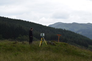
In June 2014 the ACCORD project worked together with the Colintraive and Glendaruel Development Trust (hereafter CGDT). The CGDT is governed by a Board of Directors and members are elected by the community. Currently CGDT has approximately 40 members, open to all those who are permanently resident in Colintraive and Glendaruel and on the electoral roll. The Archaeology and History sub-group of the CGDT, which has around 12 members, was founded following the purchase of the Stronafian Forest as a social enterprise and after a very successful Archaeology Scotland Adopt-a-Monument workshop held in November 2013. In June 2014, as part of the ACCORD project, together with these individuals we laser-scanned a Neolithic/Bronze Age chambered cairn that was covered in high grassy vegetation, less than ideal conditions that would likely result in an ambiguous visualisation. The archaeologists in the room, me included, had to be persuaded but it was clear that the community's desire to have this record outweighed the technical barriers in our way. This cairn was located in the community owned forest, which they had purchased less than one year earlier (Lephinkill cairn Canmore ID 40540) (Figure 1). There were plans already underway to create a series of woodland walks that would culminate at the cairn, the main focal point in the forest on a clear ridge overlooking the valley below. The group were keen to validate the cairn by relating to archaeology as a scientific endeavour. Indeed, since the creation of the laser-scan image this area has been re-named the 'Neolithic Quarter' by the community - it is clear that this archaeological act has had a very real and long-lasting impact on how people define and promote this place.

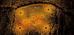
Why use lasers, and not just measuring tape, drawing or writing for that matter? In the first focus group as part of the design process, before going out on site, a need for accuracy and objectivity was not necessarily raised as important. Rather the desire to 'spiritually' connect with the cairn, an attempt to get more 'in touch' by exploring 'the story' of their local landscape which they had recently invested in was reiterated again and again. But, lasers prevailed in this case and on reflection it is clear that this sits uneasily with their clearly expressed personal and emotional ties to this place. Nevertheless, for the group the stakes were high and therefore the best technology was to be deployed. Again, this raises the point already made above regarding our collective (including archaeologists more generally) fetishisation of evermore increasingly accurate, automated and thus, it is assumed, better technologies. Although other techniques may have been more successful at representing the cairn, ultimately the representation was not what was important; it was the performance of recording using the latest state-of-the-art technology which, it was felt by most of the community participants, would be testament to their emotional, ideological and economic investment in this place. The scan (reproduced as Figure 2) is therefore a valuable record when mindful of the process of its making, but is not archived on the Archaeology Data Service alongside the other records we made together, as it was not thought to be a useful product to others due to its inaccuracy (as predicted).


Laser scanning does not allow short-term community interventions and participation easily, as it requires specialist knowledge to operate. Nevertheless, the community were co-directors and audience to an archaeological process in the performance of laser scanning of the cairn. Although I think it is fair to say that the participants would not define themselves so, this chimes with Shank's provocation 'we are all archaeologists now!' (Shanks 2013; Holtorf 2015). One individual described how 'the monument was brought to life'; trudging through the overgrowth, balancing the tripod and watching the flutter of the laser beam across the undulating ground. The scan gave those who were involved in this process access to a particular relationship with the landscape that often only archaeologists are privy to. This intangible experience enhanced their already intimate tie to this place and is testament to their investment in Stronafian. This, however, is not obvious on viewing the final product.

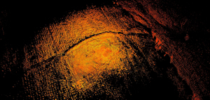
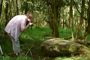
We also employed photogrammetry and Reflectance Transformation Imaging (RTI) to examine a boulder (Canmore ID 40460) with Neolithic rock-art which had never been seen by the group before (Figure 3). This stone was located in the 'spiritual heart' of the forest, and after wandering around with little information to direct us we came across the likely candidate. Here, the technologies themselves afforded participation in the recording. Everyone in the community had an important role in making the RTI, whether this was using the torch-light, pinning down the tarp, or setting the camera parameters. In this case, the technology encouraged the group to move from outside the process into the frame. Being involved also encouraged a more emotive response to the final results – 'it's like magic!' as one participant exclaimed
Internet Archaeology is an open access journal based in the Department of Archaeology, University of York. Except where otherwise noted, content from this work may be used under the terms of the Creative Commons Attribution 3.0 (CC BY) Unported licence, which permits unrestricted use, distribution, and reproduction in any medium, provided that attribution to the author(s), the title of the work, the Internet Archaeology journal and the relevant URL/DOI are given.
Terms and Conditions | Legal Statements | Privacy Policy | Cookies Policy | Citing Internet Archaeology
Internet Archaeology content is preserved for the long term with the Archaeology Data Service. Help sustain and support open access publication by donating to our Open Access Archaeology Fund.