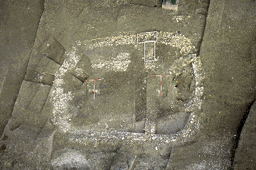
Fig. 2.1 High level photograph of a large Late Roman '?shrine' with flattened apses at either end, cut into the western side of the dry valley running south from the settlement
Following the discovery of an Early Anglo-Saxon settlement at West Heslerton, North Yorkshire in 1982, on a site that was suffering from active plough damage, a proposal was submitted to English Heritage (formerly DoE) which included three options:
There were excellent academic grounds for excavation and this option was selected. Excavation began in 1986, and by the completion of the excavation at the end of 1995 an area of more than fourteen hectares had been examined during seven seasonal summer excavations, working with a largely volunteer work force. The project was funded by English Heritage as part of the national rescue archaeology programme and received additional assistance in kind from a number of companies in the electronics and computer industry, various individuals, and from the American charity Earthwatch. The excavation of the settlement followed on from the excavation of an associated cemetery utilised between c.AD 475 and c.AD 625, the report on which has now entered the final publication stage (Powlesland and Haughton, forthcoming).
At the start of the project, the only large-scale, recently excavated and published excavation of a similar site in England was that at West Stow in Suffolk, and the evidence from this site and other partially excavated sites indicated that the normal pattern for early Anglo-Saxon settlement was of small loosely clustered groups of structures demonstrating a shifting settlement pattern (West 1985). The only other very large site to have been examined, Mucking, Essex, remained unpublished. The view at the time was that Mucking, located in an important position towards the mouth of the Thames, was exceptional on account of its location and its interpreted role as a primary settlement site, a link in the migration process which brought the Early Anglo-Saxon population to England (Jones 1979; Hamerow 1993). Based on the evidence to hand it was suggested that the West Heslerton settlement was unlikely to cover as much as 10ha. which would make it a very large example of this class of site.
The evidence recovered indicates that the site, far from being that of a small hamlet or cluster of farms demonstrating a shifting settlement pattern, was a large, planned, or at least highly organised settlement, incorporating characteristics which might be interpreted as proto-urban in nature, laid out during the late 5th century. Prior to the final season it was considered most likely that the settlement had developed from a high status core at the southern end, where it may have overlain a very late Roman farmstead or possible 'Villa'. By the middle of the 6th century the form and extent of the settlement changed and the site contracted to cover only the core area, the layout of which appears to have been defined by the boundaries first established during the Roman period.
That the site developed upon an earlier Roman site cannot be questioned; however, neither the humble farmstead nor the grand 'villa' are not present. The dry valley that runs towards the foot of the Wolds from the spring at the centre of the southern half of the settlement was the setting for the construction of at least two structures best described as shrines (Fig. 2.1) and for a major and associated landscaping operation which re-modelled the entire valley.
The picture that is now emerging is currently unparalleled, but this most likely reflects not so much an exceptional status for West Heslerton as the scale of the archaeological investigation. It was agreed at the outset of the project that total exposure of the settlement area was necessary with sampling of the archaeological deposits being applied to the exposed features; had this strategy not been applied it is unlikely that the nature of the site could have been correctly understood.
The scale of the project and quality of data returned have far outstripped the initial projections which, while based on the evidence then to hand, could not have anticipated either the nature or scale of evidence recovered.

Fig. 2.1 High level photograph of a large Late Roman '?shrine' with flattened apses at either end, cut into the western side of the dry valley
running south from the settlement
© Internet Archaeology
URL: http://intarch.ac.uk/journal/issue5/westhes/2-1.htm
Last updated: Tue Dec 15 1998