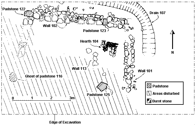
Figure 5: Plan of structure 1
Interest in the site was generated when, in 1982, it became apparent that some form of rescue excavation was necessary to salvage the remains of a small structure that was being rapidly destroyed by deep ploughing and subsoiling. This activity on the slight terrace had revealed much building stone, traces of a hearth and a number of distinctive lead net weights.
An evaluation of the site was made in October 1982 with a small trial trench measuring 5m by 4m, in the area producing the most building rubble. The trench revealed the corner of a stone structure, a hearth and a drain, showing that some undisturbed deposits survived.
At this time it was clear that if the site had been ploughed twice more, the structure would have been completely destroyed. A full excavation of the site was organised accordingly for the following autumn, 1983 (Figure 5).

Figure 5: Plan of structure 1
The objectives of the excavation were to salvage and record the surviving deposits before their destruction, to test McDonnell's hypotheses concerning the date and function of the site, and to gather, study and publish all the known finds. Furthermore, waterlogged organic deposits from the pond itself were sought so that an environmental appraisal of the area could be made.
The main excavation (figure 5) examined the area covering the terrace measuring 10m by 6m. This area was stripped to natural subsoil, which was a heavy orange clay (number 121 - not on plan). On top of this were the stone footings of a building. There were no signs of foundation trenches.
The northern footings (102) 0.45m wide by 5.80m in length, consisted of two courses of unmortared, roughly hewn, limestone slabs (see plan). Constructed into the wall were two flat sandstone slabs (122 and 123) that were evidently re-used. Both were well dressed and may have originated from the nearby Abbey complex. Slab 122 measured 0.5m by 0.3m and was located at the western end of the wall. Slab 123, however, measured 0.3m by 0.4m and was located about 1.6m from the eastern end of the wall. The interpretation of both these stones is that they acted as padstones, supporting two timber uprights that formed the northern side of a framed superstructure. The footings are interpreted as sleeper walls for the lower horizontal sill beams of the frame.
The eastern footings (101) were similarly built and measured about 0.45m wide and 4m long. Slight traces of a western wall were apparent, but nothing survived of the supposed southern wall fronting the pond.
The only evidence for the south-western corner of the structure was the impression in the natural clay of a limestone slab (116) measuring approximately 0.4m by 0.5m. This was, however, located 4m from the northern wall (see figure 5).
Another flat limestone slab (125) measuring about 0.5m across, also interpreted as a padstone, was found 4m south of the northern wall but 1.6m from the southern end of the eastern wall, and 4.7m from slab 116. A line drawn between these two supposed southern padstones runs parallel to the northern wall and it is suggested that they represent the line of the southern wall of the building.
Within the structure three unworked pieces of limestone (113), measuring 0.2m across, ran north-south for approximately 0.8m. This feature is interpreted as either the slight vestiges of an internal subdivision or, perhaps more likely, the ghost of a robbed timber subdivision.
An area measuring 0.7m by 0.7m of closely spaced thin limestone slabs (104) embedded in the natural clay was located in the area between the ?partition wall (113) and the eastern wall (101). The upper surface of this feature showed signs of continued burning, suggesting that it had been a hearth. Evidently much plough disturbance had taken place over the hearth because, according to the farmer, the hearth once existed as burnt stones covering a length of 8 feet (2.5m) (McDonnell 1981, 30).
Despite the disturbance caused by ploughing and subsoiling activities in the area of the hearth, three layers of soil containing ash and charcoal (contexts 114, 119 and 120) were distinguishable. These deposits were located near the hearth and it seems reasonable to interpret them as occupation debris deposited as a result of the continued use of the hearth. Context 114 contained a scrap of lead - SF (Small Find) 87. Context 119 contained two scraps of lead (SFs 122 and 126), one type 2 lead net weight (SF 123) and an iron knife blade (SF 124).
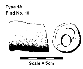
Figure 7: Net weight of type 1A - Find No. 10
Located in the larger of the two 'rooms' of the structure was context 117, a mixed brown loam with stones, tile and daub flecks which overlay natural. This layer contained three lead scraps (SFs 112, 116 and 120), one type 1b net weight (SF 111), six type 2 net weights (SFs 108, 109 (figure 11), 110, 113 (figure 12), 119 and 121) and an iron door stud (SF 117).
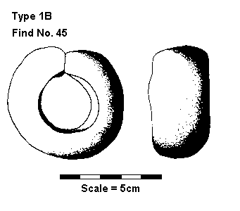
Figure 8: Net weight of type 1B - Find No. 45
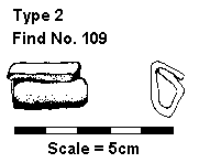
Figure 11: SF 109 - type 2 net weight
This surface was the nearest thing to a floor surface that was found in the structure. The finds implied that the area may have been used as a workshop in which nets were handled and/or weights produced.
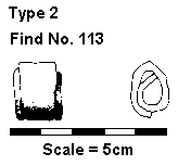
Figure 12: SF 113 - type 2 net weight
Outside the structure, a small 'U' shaped ditch or gully (107), about 0.5m wide and no more than 0.3m deep, ran parallel to the north wall of the structure, then turned through approximately 90 degrees to run parallel with the eastern wall. The feature petered out only half-way along this wall. The cut was filled with a layer of clayey loam with tiles and many water-worn boulders. This type of fill would allow water to pass freely. The interpretation of this feature, on the basis of its location and fill, is that it was a drainage ditch that carried surface water from the northern slopes away to the east of the structure. The fill also contained some lead scraps. This drainage ditch may have been cut as part of remedial work to the main structure since the ditch clearly cuts pre-existing 'use' surfaces.
The eastern segment of 107 cuts through a series of deposits that greatly resembled the natural subsoil but contained finds and pottery. These contexts were labelled 106, 111 and 124 and were all clays containing varying amounts of loam. Context 124 contained two lead scraps (SFs 127 and 128). These deposits are interpreted as 'use' surfaces and probably represent no more than the disturbance of the natural subsoil through trample etc.
Further possible evidence for such remedial work inside the structure may be indicated by a simple line of stones (110). The line protrudes no more than 0.15m from the northern wall and occurs only within the smaller 'room'. The stones overlay deposits taken to represent earlier 'use' surfaces (114, 117 and 119). However, the interpretation of these stones remains problematic.
Abutting the hearth and feature 110 were a variety of flecked clay deposits containing varying amounts of ash, charcoal, tile and loam (108, 109, 112, 115 and 118). These deposits appear to represent the last vestiges of occupation within the structure and, indeed, contain more of the same distinctive lead net weights. Context 112 in particular contained SF 107, a type 1a weight (see figure 7), SF 95, a type 1b weight (see figure 8), SF 96, a type 2 weight (see figures 10, 11 and 12) as well as several waste scraps of lead.
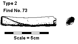
Figure 10: Net weight of type 2 - Find No. 73
Context 103 overlies the hearth and the north and east walls of the structure. It contained mixed mottled loam with ash, tile and charcoal and, by association with the main structural features, is interpreted as the abandonment of the structure. Above this deposit was thick modern ploughsoil (context 100).
Three other cuttings were made at the same time as the main trench was excavated. These were 1m square trial pits and were intended to sample the hillside south of the structure and attempt to isolate the edge of the fishpond (transect line). Area 2 was located about 6m from the southern edge of the main area 1 (see Figure 4) and was excavated to a depth of 0.7m. At this depth a level surface of tightly packed pebbles with some tile was found (context 202). This was interpreted as a hardstanding, possibly a work area relating to the structure.
Area 3 was about 35m south of the southern edge of area 1. A number of dark organic layers containing twigs and other organic matter (contexts 302, 303, 304 and 305) were excavated to a depth of over 1.5m. Samples were taken for an environmental evaluation and an interim examination has recognised hazel and alder.
Area 4 was located between areas 2 and 3. This was excavated down to a depth of 1.5m and nothing but sterile natural orange clay was encountered.
© Internet Archaeology
URL: http://intarch.ac.uk/journal/issue7/kemp/2.html
Last updated: Thu Dec 16 1999