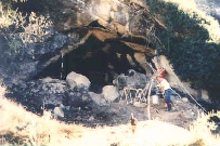
 Plate 1: Cueva Negra and the Río Quípar. (Photo M.J. Walker)
 Plate 2: Cueva Negra in 1990 showing large fallen blocks still in the entrance. (Photo M.J. Walker)
We began fieldwork at Cueva Negra del Estrecho del Río Quípar in 1990, at Sima de las Palomas del Cabezo Gordo in 1992, and have excavated yearly at each site, helped along by zealous students, Spanish Government grant PB92-0971, Murcia's regional authorities (grant PSH93-052 and annual excavation support) and also, from 1995, by Earthwatch Institute volunteers.
Cueva Negra del Estrecho del Río Quípar ("Black Cave of the R. Quípar gorge, or strait") lies at 750m above sea level in the NW Murcia uplands near La Encarnación village in Caravaca municipality. The large north-facing rock-shelter lies in Upper Miocene fossiliferous sandy limestone, 40m above the river as it leaves the gorge (Plate 1, Plate 2).
 Plate 1: Cueva Negra and the Río Quípar. (Photo M.J. Walker)
 Plate 2: Cueva Negra in 1990 showing large fallen blocks still in the entrance. (Photo M.J. Walker)
Its name comes from its soot-blackened roof, due to Civil-War (1936-9) fugitives who dug out a deep hideaway pit, storage-pits, and a flimsy lean-to structure, in sediment whose late Quaternary age was demonstrated by cursory excavation in 1981 (Martínez et al. 1989). Our project has identified Neanderthal remains: 6 adult teeth and ulnar and humeral shaft fragments (Plate 3, Plate 4).
 Plate 3: Cueva Negra. Neanderthal incisor CN-1. Scale in 1cm divisions. (Photo M.J. Walker)
 Plate 4: Cueva Negra. Neanderthal ulnar shaft CN-3. Scale in 1cm divisions. (Photo M.J. Walker)
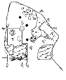
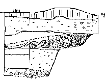
A 25m2 area is under excavation, though apart from a 3.5m deep test-pit only upper layers have been explored (Figure 3, Figure 4). The sedimentary fill extends outwards forming a narrow hanging terrace, and is 8m thick where that has been cut away by erosion in response to fluviatile rejuvenation.
 Figure 3: Ground plans of Cueva Negra
 Figure 4: Synoptic stratigraphical sections of Cueva Negra
It corresponds to a broad terrace on the opposite side of the valley. It is the ubiquitous glacis-terrace B that recurs throughout valleys in the Segura basin where its surface lies 35-40m above today's rivers. Radiocarbon dating suggests it formed until 40,000 years ago when fluviatile rejuvenation supervened (Cuenca et al. 1986; Cuenca and Walker 1986; 1995), though from the onset of the upper pleniglacial stage, around 30,000 years ago, an even more widespread glacis-terrace A has formed, leaving a surface 8-15m above today's rivers - and also traces near our cave. Sediment in Cueva Negra and its middle palaeolithic artifacts were probably deposited in lower pleniglacial times 75,000-40,000 years ago if, as is likely, glacis-terrace B only began forming once the last interglacial period was over (say 115,000 years ago). Geophysical dates are required, so during a 1997 British Council-Spanish Government "Anglo-Spanish Integrated Action" Professor of Prehistoric Archaeology at Oxford, Derek Roe, with geologist John Mitchell took sedimentary cores controlled by gamma ray spectrometry for attempts at direct optical sediment dating by geophysicist Professor Michael Tite at Oxford's Research Laboratory for Art and Archaeology, where charcoal was also submitted for accelerator radiocarbon investigation by Professor Robert Hedges.
The cave fill comprises erosion products of Miocene rock, with a significant proportion of fine, angular, microscopically-pitted, silt-size particles comparable to wind-blown loess. No sorted gravels have yet been found that might have been left had a Pleistocene River Quípar meandered into the cave across a swampy floodplain formerly occupying the surface of today's glacis-terrace B. Angular scree and fallen blocks occur, maybe the result of earthquakes or frost-shattering: tremors are common in SE Spain and frosts occur at our upland cave in late autumn and winter even in today's interglacial. Cueva Negra was probably never inhabited continuously throughout the year. Mountains rising to 1,500m overlook our north-facing cave at 750m asl, which must have experienced bitterly cold, ice-age winters. Mountains rise to 2,000 metres only 30km away (Figure 1), and 150km to the south 3,400m high Sierra Nevada peaks were surrounded by sporadic ice-age glaciers above 2,000m.
Pollen analyst Dr José Carrión at Murcia University could obtain no pollen from an open 1981 section he sampled at Cueva Negra. Pollen from the well-dated Carihuela Cave in Granada - even higher than Cueva Negra and even closer to the Sierra Nevada - records a mesothermophilous (warmth-loving in a balanced moisture regime) flora during the last interglacial period and noteworthy replacement of thermophilous taxa by a herbaceous steppe flora during both lower and upper pleniglacials of the last ice age (Carrión, 1992); similar pollen findings come from the well-dated Padul bog in the Sierra Nevada foothills (Pons and Reille 1988). However, the Carihuela pollen also points to interpleniglacial expansion of mesothermophilous refuges, as does pollen from Beneito Cave in Alicante (Carrión and Munuera 1997) and elsewhere in Mediterranean Spain (Carrión et al. in press). Ice-age refuges can therefore be envisaged of mesic and thermic plant taxa in the Quípar valley near Cueva Negra. As will be mentioned later, some birds found at our site required acorns for their diet, implying the presence of Quercus stands nearby.
Today the NW Murcian uplands and valleys support a thermomediterranean flora with some supramediterranean taxa, bioclimatically-speaking (Figure 2). Three Mediterranean biogeographical provinces overlap here (Murcian-Almerian, Baetic, Castilian-La Mancha-Maestrazgo). The climate is sub-humid to semi-arid with 2,600-2,800 hours of sunlight a year. Mean January temperatures fall to 2º-4ºC, though mean July temperatures rise to 20º-22ºC. Large game in NW Murcia today includes plentiful wild boar and a handful of highly-protected red deer, whilst Spanish ibex occurs 50km away in the Sierra del Segura.
© Internet Archaeology
URL: http://intarch.ac.uk/journal/issue5/walker/2.0.html
Last updated: Wed Dec 23 1998