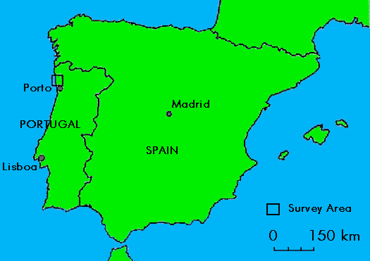
Fig. 2.1. Location of the Ave valley region, north-west Portugal.
Fig. 2.2. The Ave valley region (select link to zoom into survey area)
(javascript must be enabled to view image)

Fig. 2.1. Location of the Ave valley region, north-west Portugal.
Fig. 2.2. The Ave valley region (select link to zoom into survey area)
(javascript must be enabled to view image)
The area selected for the survey comprised part of the basin of the Rio Ave which is located in the Entre-Douro-e-Minho region of northern Portugal (Fig. 2.1). The region lies on the Atlantic seaboard of the Iberian peninsula at a latitude of 41° 30' North. The Rio Ave discharges into the Atlantic at Vila do Conde c. 20km north of Porto. The survey area itself comprised a zone c. 20km wide running inland from the coast, bounded to the south by the Rio Ave and to the north by the Rio Cávado (Fig. 2.2). Initially, it was planned to sample the area by walking a series of regularly spaced 1km wide northsouth transects at intervals from the coast to the interior. However, the first season's fieldwork in 1994 demonstrated that the fields were too small and the landscape too broken for a good sample of the land in the region to be obtained in this manner. As a result, the sampling strategy and transect design were modified and the survey area reduced to a smaller block. This was defined as the area covered by the 1:25,000 maps in the Carta Militar de Portugal series listed in Table 2.1.
| Sheet 68 | Esposende |
|---|---|
| Sheet 69 | Barcelos |
| Sheet 82 | Póvoa de Varzim |
| Sheet 83 | Vila Nova de Famalicão |
| Sheet 96 | Vila do Conde |
| Sheet 97 | Bougado (Santo Tirso) |
Within this area the zone covered was thus approximately 20km northsouth by 24km east-west, the eastern limit being defined by the edge of the map sheet (easting 405 on the map grid).
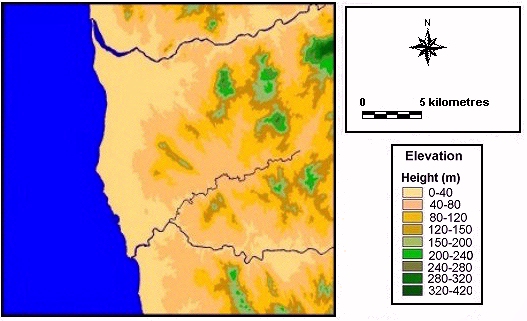
Fig. 2.3. Topography of the study area
The region lies on the western side of the Iberian peninsula and is dominated by hills and mountains cut by a series of river valleys. The terrain is uneven and much of it heavily wooded, with the grain of the landscape running broadly north-east to south-west (Fig. 2.3). The highest land lies in the north-eastern part of the area where the ground rises to 411m. Two ranges of uplands divide the basin of the Este from those of the Cávado and Ave. The peaks of these hills decrease in altitude towards the west, but a substantial part of the land still lies above 150m. Much of the survey examined this area, which is dominated by low hills and well-watered small valleys that are exceptionally fertile. Towards the coast the land is rather flatter, with the coastal plain generally lying below 40m and varying in width from 4km in the south to 10km in the north. In the latter zone the shore is bounded by sand dunes.
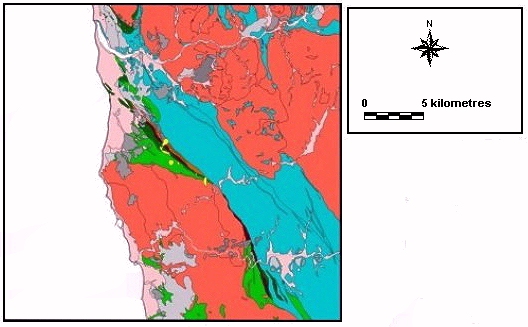
Fig. 2.4. Surface geology of the study area (geology key)
The geology of the region is dominated by two zones of granite, between which is sandwiched an area of metamorphic rocks which runs south-eastwards inland from the coast between Navais and Esposende (Fig. 2.4). The granites differ in composition, varying from medium/coarse to fine-grained (Carta Geológica de Portugal sheets 9A and 5C). These represent igneous intrusions of the Hercinian phase. These intrusions baked the intervening, predominantly fine-grained rocks, which had been deposited in the Ordovician, Devonian and Silurian periods. This metaphorpic zone comprises principally schists, greywackes quartzites and conglomerates which contain a series of mineralised veins producing gold, tin, zinc and iron (amongst other minerals). In the coastal zone both the granite and metamorphic rocks are overlain by a series of Quaternary beach deposits and sand. Similarly, Quaternary fluvial deposits are found on some of the valley floors. The zone of metamorphic rocks is somewhat less resistant to erosion than the granites and its location is clearly visible on the topographic map (Fig. 2.3) (see section 2.7). The soils of the area have not yet been mapped in detail but are generally humic cambisols which vary in character depending on the parent rock beneath.
The drainage follows a predominantly west or south-westwardly axis with a series of relatively short, fast-flowing rivers draining from the mountains of the Sa de Marão. The Rio Ave rises in the Cabreira-Alturas range near Vieira do Minho at above 1250m and has a course some 70km in length (which has been altered by the insertion of hydro-electric dams). In its upper reaches the valley is relatively narrow and runs through rugged terrain. In the middle section the valley is broader with steep, wooded slopes and extensive artificial terracing. In its lower course, in the survey area, the valley broadens although the terrain remains broken and hilly. At Alves, to the south-east of Vila Nova de Famalicão, the Ave has its confluence with the Rio Vizela and thence the relatively broad river flows in a wider valley west to the coast at Vila do Conde. Near Tonguinho, about 5km from the coast, the Rio Este joins it, flowing in from the north-east. This river is much smaller than the Ave, rising near Este at an altitude of 450m, only a few km to the east of Braga. Although a relatively minor river it is of significance as it bisects the study area diagonally from north-east to south-west. In common with the other rivers of the region, it flows across a series of geological faults so its valley is divided into compartments, with broader stretches of valley separated by narrower gorges (for instance at Gondifelos). The fast-flowing Rio Cávado, on the northern edge of the study area, is a more substantial river which rises north of Montalegre in the Gerês-Larouco mountains at c. 1500m before flowing about 90km to discharge into the sea to Esposende. In their lower courses, both the Cávado and Ave flow relatively broad and deep and their estuaries have provided locations for the development of the two fishing ports.
The region's present-day climate is strongly affected by the Atlantic. It is mild in the winter, with mean January temperatures in excess of 7°C and mean July temperatures above 17°C. The annual rainfall is high, with the mean total approximately 1200mm and an average of more than 120mm per month falling each month between October and April. Equally significant is the observation that, on average, annually rain falls on three out of every ten days (Naval Intelligence Division 1941, 223). Summers are dominated by moderate temperatures, with little rain but high humidity. Spring and autumn are cool with alternating rainy and bright days. Winter is cool, humid and very rainy.
The present day landscape is dominated by lush vegetation of evergreen woodland and small arable fields. The natural woodlands are dominated by deciduous and evergreen oaks with a range of associated species (hazel, ash, hawthorn, holly, chestnut and yew). In recent years, the rapid spread of Eucalyptus has changed the character of the woodlands, many of which are now dominated by these trees which produce an environment which is not conducive to a flourishing undergrowth (Fig. 2.5). Clearings are densely colonised by species such as broom, gorse, fern, box and bramble. Palaeoenvironmental studies suggest that this traditional pattern predominated in the Iron Age and Roman periods (Queiroga 1992, 1618).
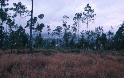
Fig. 2.5. Example of the regional vegetation, overlooking the Rio Cavado
The present day agricultural regime reflects both the physical geography of the region and the intensive use of an area which is amongst the most densely populated of the Iberian peninsula (Zalacain 1982, 1314). The arable crop regime is typified by a three-fold annual rotation. Grass is planted for animal fodder in the autumn; this is followed by potatoes which are harvested in early summer, allowing for the planting of maize which is harvested in September-October. Both the grass and maize are used as fodder for the cattle that are kept in byres through much of the year, their manure being used to fertilise the intensively cropped fields. Towards the coast this pattern of agriculture is supplemented by intensive market gardening, much of it practised on a small scale.
Aspects of a traditional agricultural regime survive in some parts of the inland and upland region, with a few peasant farmers still working small properties and using cattle rather than machines for traction. Evidence of such farming traditions is still reflected in much of the landscape by a variety of features. Most small fields are surrounded on all four sides by grape-vines, grown to form an overhanging canopy. These mixed variety vines provide grapes for the continuing small scale production of vinho verde. In some of the woodlands gorse is cropped and used for animal bedding. Small-sized fields over much of the rest of the survey area are a survival from the traditional agricultural regime but the utilisation of the landscape is rapidly changing. In many areas, particularly on the valley floors and around the margins of the woodlands, larger fields are being created where maize can be grown and harvested more efficiently using machinery. This often involves the removal of the vines between the fields and the development of a much more open landscape. Equally, the use of machinery has led to the abandonment of smaller terraces on the steeper slopes with the result that Eucalyptus woodland is encroaching.
The intensive use of fodder crops necessitates the construction of substantial semi-subterranean silage clamps on field edges. The large-scale use of maize cultivation in the summer months has also resulted in a demand for irrigation which has led to the excavation of large wells and cisterns (see sect 2.7). Finally, a greater commercial emphasis has been placed on vine cultivation, with large-scale single grape variety vineyards taking the place of traditional growing methods. All these activities have resulted in considerable ground disturbance, as well as alterations to the appearance of the landscape.
The other major feature of the region is the spread of human settlement. In areas along the coast this is most notable with the construction of new roads, industrial estates and housing. In the more inland areas, development is less spectacular but omnipresent. Thus, there are very large numbers of new houses lining many of the roads throughout the region, even in the most rural of locations.
At the beginning of this project, the area was examined to establish the extent to which it was likely to have been affected by geomorphological change since the Iron Age. This evaluation suggested that there were likely to have been major localised events, such as periodic wildfire episodes and subsequent soil loss from rainfall (Shakesby et al. 1996; Bathurst et al. 1996), that could have resulted in the erosion of some areas and the burial of sites in others. However, the broken character of the landscape suggested that it would be difficult to predict the areas most likely to have been affected. It was therefore decided to examine the geomorphology of the region as the survey progressed to establish the impact of landscape change on each of the areas examined.
The procedure followed was therefore to examine the landscape in each of the areas visited and note features such as terracing, soil depth and landforms that suggested landscape change. In the 1995 season the team was accompanied by Clare Ellis, a specialist in landscape change, whose observations complemented those made by other members of the team.
As the project progressed, two things became clear. First, the changes in the landscape provided a series of opportunities to look at geological sections (Table 2.2). Second, two zones could be defined that had regularly been affected by landscape change.
| Location | Situation | Observations |
|---|---|---|
| Beside Field 108 | Situated on alluvium deposits of the Rio Ave. | On the floodplain of the Rio Ave, a farmer showed us a substantial bog oak recovered from beneath c.1.5m of alluvium. |
| Field 125 | Situated on schist in the middle of the valley floor in a tributary of Rio Ave. | Trench, hand cut by farmer in valley floor (Fig. 2.6) to a depth of c. 4m. Section cleaned and drawn showing a series of episodes of rapid deposition. Depth of deposits suggests problems of rapid erosion on argillaceous schists and greywacke. |
| Field 187 | Field situated on micaceous granite. | Enormous machine-cut trench for insertion of a well (Fig. 2.7). Section revealed c. 2m of weathered granite beneath the agricultural horizon. The upper part of this showed a series of layers of freshly eroded granite. In the base of the section, two channels were filled with organic material. |
| Field 295 | Situated on micaceous granite, overlain by deep soil produced by terracing activity. | Foundations for a house cut into the slope beside the road. A buried soil at a depth of c. 1.8m was overlain by a terrace accumulation. |
| Field 394 | Located on micaceous granite. | Large machine-cut trench for insertion of a well. Partly backfilled. Section showed c. 1.5m of weathered granite and with an infilled palaeochannel. |
| Motorway crossing of Rio Ave at Vila do Conde | Situated on alluvium deposits near the centre of the valley of the Rio Ave. | Foundation trench for motorway bridge support on the floodplain to the north of the river revealed c. 2m of fine, waterlain clays above a sequence of thin layers of coarser granitic sands. The section exposed c. 0.5m of these; they continued beneath the base of the trench. |
The geomorphological observations noted in Table 2.2 confirmed the view that landscape change was generally likely to have been influenced by local factors, although chemical erosion of the granites had the potential to produce considerable depths of soil throughout the region.
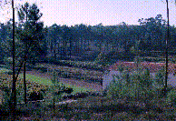
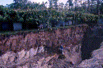
Fig 2.6. (l) Field 125, location of hand-cut trench. Fig 2.7. (r) Field 187, machine-cut trench for the insertion of a well.
In addition, two sets of circumstances were identified which suggested regular patterns of alteration to the landscape. Information from valley floor sections consistently confirmed a strong likelihood that these areas had experienced significant alluviation and were unlikely to produce evidence of Iron Age or Roman landscapes. This conclusion was upheld by subsequent fieldwalking. Second, the only observation on the schist came from the farmer's trench in field 125, where almost 4m of deposits had accumulated in a very shallow upland valley (Fig. 2.6). This suggested a potentially greater problem of erosion on the schist than on the granite. It was thus concluded that the geomorphological factors rather than differences in ancient settlement patterns might account for the small number of previously known archaeological sites from the schist areas. This observation is discussed further in relation to the survey results.
© Internet Archaeology
URL: http://intarch.ac.uk/journal/issue9/millett/geo.html
Last updated: Sat Dec 30 2000