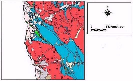
Fig. 6.23. Distribution of previously known sites in relation to geology (view key)
The distribution of settlement as understood prior to the survey showed a distinctive pattern with Iron Age activity focused on defended hilltop sites (castros). Although a change in settlement distribution was evident in the Roman period with increased emphasis on lower valley terraces, excavation at some castros also indicated substantial continuity of settlement.
The distribution of sites discovered during the survey suggests a more complex pattern of settlement continuity and relocation across the region. Iron Age ceramic concentrations demonstrate the existence of sites away from the castros. Settlement continuity into the Roman period occurs both at these rural sites and at castros. However, settlement relocation also occurs with an increased emphasis on lower valley terraces. However, the site locations demonstrate the continued importance of castro sites as focal points in the settlement system. Settlement is directly affected by geology, a variable which is readily visible in the distribution of Iron Age sites. A detailed analysis of the pattern of settlements known prior to the fieldwalking was undertaken by Strutt (1998; 2000). The aim of the present analysis is to assess the distribution of Iron Age and Roman material across the landscape, including the fieldwalked transects, and to explore the spatial and temporal patterns using intuitive and quantitative analytical techniques. Forty-eight new settlement locations were identified (sites 1/1 - 1/17 and 2/1 - 2/31: see 6.2.1). Of these, twenty-seven had high densities of Iron Age pottery fabrics, and forty-five had high Roman fabric densities.
Strutt's study (1998; 2000) provided statistical analyses of the distribution of the sites known prior to the survey (as noted in Section 3). These analyses comprised: (a) Chi-squared analysis of settlement distribution in relation to geology, (b) a quantitative classification of settlements comparing locational factors, and (c) an assessment of trends in both the intervisibility of settlement locations and cost of movement over the terrain between them. In the present study the information from these analyses is summarised, together with the results of similar analyses of the locations of sites discovered in the fieldwalking survey. In the analyses based on geology, the two datasets have been dealt with separately as the proportions of the different geologies differed between the sample transects and the whole survey area. For other locational analyses all eighty-eight settlement locations can be considered together.
Results of the Chi-squared test indicate an uneven distribution of archaeological material over the study area. This is supported intuitively by the absence of archaeological remains on the argillacious schists of the region.

Fig. 6.23. Distribution of previously known sites in relation to geology (view
key)
The distribution of sites known prior to the survey across the region appeared uneven (Fig. 6.23). A majority of the settlements are situated on micaceous granite (80%), with fewer on the fluvial terraces (2.5%), schist (2.5%), alluvial deposits (12.5%) and mineral veins (2.5%). Each of the percentage values for the schist, fluvial terraces and mineral veins account for a single site in each period. The small number of sites on the schist was particularly noticeable as this geology accounted for a large proportion of the area (Table 6.1).
| Geology | Sites known prior to the survey | Newly discovered sites | All sites |
|---|---|---|---|
| Micaceous granite | 32 (80%) | 39 (81.25%) | 71 (80.7%) |
| Schist | 1 (2.5%) | 5 (10.4%) | 6 (6.8%) |
| Fluvial terraces | 1 (2.5%) | 3 (6.25%) | 4 (4.5%) |
| Alluvium | 5 (12.5%) | 1 (2%) | 6 (6.8%) |
| Mineral veins | 1 (2.5%) | 0 | 1 (1.4%) |
| Total | 40 | 48 | 88 |
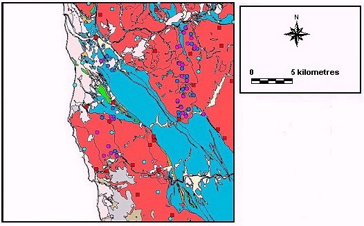
Fig. 6.24. Distribution of all archaeological sites in relation to geology (view
key)
Comparable patterns were noted for settlements discovered in the survey (Fig. 6.24). Of the total number of ceramic concentrations, 81.25% are located on micaceous granite, 10.4% on schist, 6.25% on fluvial terraces, and 2% on alluvial deposits. This general pattern was repeated when all sites were included (Table 6.1). These figures, together with the mapped distributions clearly illustrate the effect of surface geology on the distribution of archaeological material (Fig. 6.25).
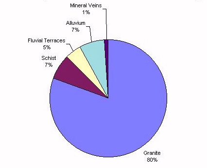
Fig. 6.25 Distribution of all settlement locations in relation to geology
A Chi-squared test was used to evaluate quantitatively the distribution of sites known prior to the survey in relation to geology. A Chi-squared test for a single classification of data was used (Shennan 1997) for castros and the findspots of Roman material, on the basis of the following null hypothesis:
| H0 | settlements are equally distributed across the geology |
| H1 | settlements are not equally distributed across the geology |
The test was carried out using the four main geological formations as a basis for the expected and observed settlement values (Tables 6.2 - 6.3). Because of the small proportion of the landscape accounted for by the mineral veins, they have not been distinguished from the granite in which they were located in these analyses.
| Geology | Granite | Schist | Alluvium | Fluvial terraces | Mineral veins | Total area |
|---|---|---|---|---|---|---|
| Area (m²) | 312481013.6 | 201532434.5 | 61299868.49 | 60060408.93 | 866128 | 636239854.2 |
| Percentage of total area | 49.11 | 31.68 | 9.63 | 9.44 | 0.14 | 100 |
| Geology | Geology (% by area) | Observed castros | Expected castros | Observed Roman sites | Expected Roman sites |
|---|---|---|---|---|---|
| Alluvium | 9.63 | 0 | 2.3 | 1 | 1.541 |
| Fluvial terraces | 9.44 | 3 | 2.3 | 2 | 1.51 |
| Schists | 31.68 | 0 | 7.6 | 1 | 5.069 |
| Granite and mineral veins | 49.11 | 21 | 11.8 | 12 | 7.858 |
| Total | 100 | 24 | 24 | 16 | 16 |
The Chi-squared equation was used on the selected data:
chi² = Σ(O - E)² ÷ E
where O is the observed number of data and E is the expected number of data.
The resulting Chi-squared values were compared with percentage point values at a significance level of 0.05. The number of degrees of freedom used were derived by the following formula (Shennan 1997, 107):
v = (number of columns -1)(number of rows -1)
v = (4 - 1)(2 - 1)
v = 3
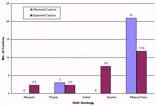
Fig. 6.26. Observed and expected number of castro sites by geology
Comparison was made with the percentage value of 7.81473 (Shennan 1997, table F). For all Chi-squared values where Chi² was greater than or equal to 7.81473, the null hypothesis was rejected. This was the case for all results, with the exception of the distribution of Roman sites (table 6.4). The results indicated that the castro sites were not evenly distributed across the geology (Fig. 6.26) although the distribution of Roman material upheld the null hypothesis. Visually, however, the distribution of these Roman sites suggested that settlement was not distributed evenly across the geology (Fig. 6.27).
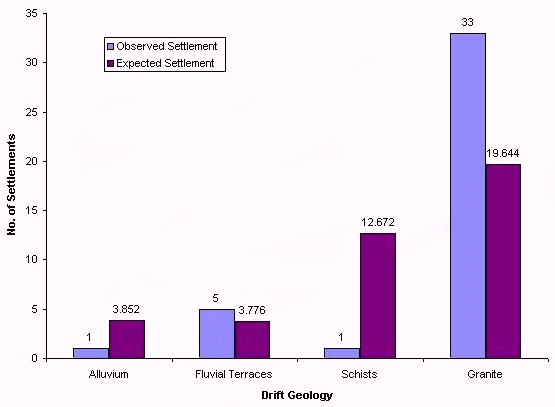
Fig. 6.27. Observed and expected number of previously known sites in
relation to geology
| Dataset | Chi² |
|---|---|
| Castros | 17.28 |
| Roman sites | 5.79 |
| All sites | 22.24 |
A similar test was undertaken to assess the distribution of the newly located sites across the two fieldwalked transects. Percentage areas of different geological types were based on the two transects alone, not the entire survey area. Based on the number of fields walked, the proportions of the main geological forms were as follows (table 6.5):
| Granite | Schist | Fluvial terraces | Alluvium | Mineral veins | Total area | |
|---|---|---|---|---|---|---|
| Number of fields | 532 | 258 | 41 | 23 | 1 | 855 |
| Percentage area | 62.22 | 30.18 | 4.8 | 2.69 | 0.12 | 100 |
From these percentage values, values for observed and expected numbers of settlements on each geological formation were evaluated. These were calculated for all Iron Age and Roman sites (table 6.6) as well as the potential sites (see 6.2).
| All sites | Iron Age sites | Roman sites | Likely sites | Probable sites | ||||||
|---|---|---|---|---|---|---|---|---|---|---|
| Obs. | Exp. | Obs. | Exp. | Obs. | Exp. | Obs. | Exp. | Obs. | Exp. | |
| Granite and mineral veins | 39 | 29.93 | 24 | 16.83 | 37 | 28.05 | 29 | 21.19 | 10 | 8.73 |
| Schist | 5 | 14.49 | 2 | 8.15 | 4 | 13.58 | 2 | 10.26 | 3 | 4.23 |
| Fluvial terraces | 3 | 2.3 | 1 | 1.3 | 3 | 2.16 | 2 | 1.63 | 1 | 0.67 |
| Alluvium | 1 | 1.29 | 0 | 0.73 | 1 | 1.21 | 1 | 0.91 | 0 | 0.38 |
| Total | 48 | 48 | 27 | 27 | 45 | 45 | 34 | 34 | 14 | 14 |
The results of the test are given in Table 6.7. At a significance level of 0.05, the null hypothesis was rejected both when all the sites were taken together (Fig. 6.28), and when they were considered by period. This is explained by the maps of the distribution of ceramics, which clearly indicate a general lack of sites on the schists. Only in the case of the probable settlement locations was the null hypothesis upheld, suggesting that the distribution of this small group of sites was not sufficiently uneven to reject the hypothesis at this particular level of significance.
| Dataset | Chi² |
|---|---|
| All sites | 9.233 |
| Iron Age sites | 8.489 |
| Roman sites | 9.977 |
| Likely sites | 9.623 |
| Probable sites | 1.085 |
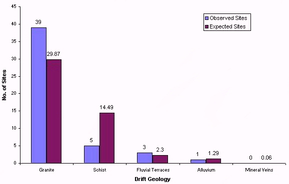
Fig. 6.28. Observed and expected number of settlements discovered in the survey, by geology
In summary, a number of factors have influenced the distributions. The distribution of settlement in the study area is strongly related to geology and very small numbers of sites are located on the schists. This distribution has probably been influenced by erosion, with soil deposition in the valleys covering sites and redepositing archaeological material. Erosion may also have influenced the settlement pattern between the Cávado and Ave.
© Internet Archaeology
URL: http://intarch.ac.uk/journal/issue9/millett/stats.html
Last updated: Sat Dec 30 2000