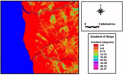
Fig. 6.29. Slope gradient coverage for study area
The aims of these analyses were to investigate the location and distribution of settlement sites and the factors that may have influenced them. Factors such as topography, proximity to drainage and availability of resources all affect settlement location. Cultural and social influences are also clearly important.
In the primary spatial analysis of sites known prior to the survey, factors of site visibility and accessibility, as well as topography, were found to have had important influences on location (Strutt 1998; 2000). However, these data were limited by the small number of sites and the lack of chronological precision. The initial analyses have been reworked, incorporating the sites found during fieldwalking. Many of the trends noted in the initial analyses are still reflected in the new results. Analysis of settlement location was carried out on the basis of several parameters: the situation of each site, its slope gradient, the slope gradient and slope aspect in the immediate vicinity of the settlement.
The topographical location of each site was categorised as follows:
The number of settlements in each category was recorded and graphical representations of the settlement locations were produced, in the form of pie charts.

Fig. 6.29. Slope gradient coverage for study area
Slope gradients for each settlement were calculated from the GIS using the slope gradient raster coverage (Fig. 6.29). Gradients were divided into categories of four-degree range, from 0 to 4° (where ground has such a shallow gradient that it is essentially flat) to values of between 28 and 32°. The category of 'immediate gradient' referred to the ground on which a settlement was constructed, whilst the 'surrounding gradient' recorded the maximum gradient of slope surrounding each settlement within a radius of 400m (Fig. 6.30).
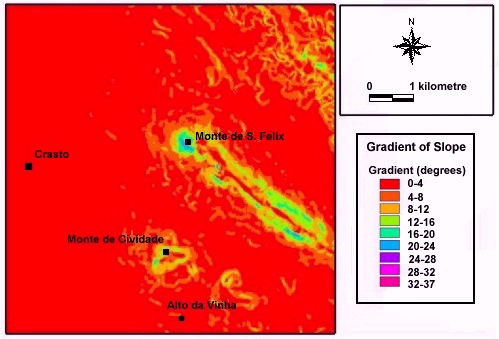
Fig. 6.30. Slope gradient for the castros at Monte da Cividade and Monte de
S. Felix
In addition the slope aspect of the location of each site was assessed, to establish whether this showed any pattern (Fig. 6.31).
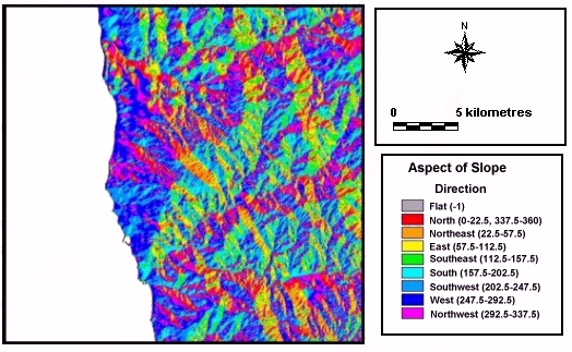
Fig. 6.31. Coverage of direction of slope aspect for the study area
Results of the analyses for the sites known prior to the survey showed a marked contrast between the locations of castros and Roman sites. The aggregate pattern of locations indicated that the majority were either on hilltop or river valley terraces (Table 6.8). These represent 75% of the total. A contrast can also be noted between different settlement types. Of the 24 castro sites, 17 (70.8%) are situated on hilltops, with a further 4 (16.7%) positioned on spurs of land overlooking the main river courses of the Ave and Cávado (Fig. 6.32). With the exception of castros which continued in occupation, no Roman sites are located on hilltops. Instead, 68.75% are situated on river valley terraces and 25% on the coastal plain.
| Situation | Castros | Roman sites | Total |
|---|---|---|---|
| Hilltop | 17 (70.8%) | 0 | 17 (42.5%) |
| River valley terrace | 2 (8.3%) | 11 (68.75%) | 13 (32.5%) |
| Spur | 4 (16.7%) | 1 (6.25%) | 5 (12.5%) |
| Coastal plain | 1 (4.2%) | 4 (25%) | 5 (12.5%) |
| Total | 24 | 16 | 40 |
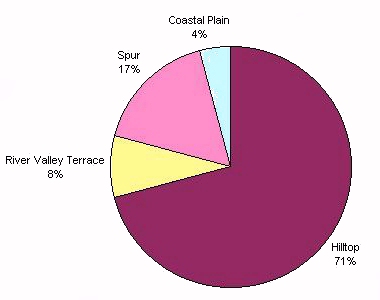
Fig. 6.32. Pie chart showing the topographical situation of castros
These findings contrasted sharply with those of the sites discovered in the fieldwalking (Table 6.9). The majority (83.33%) of these are situated on river valley terraces away from spurs and hilltops, a further 10.41% are located on the coastal plain, and 4.17% on spurs. Only one site is located on a hill top, this being the pottery and tile concentration close to the castro of Outeiro dos Picotos. Similar percentages are found when the Iron Age and Roman sites are examined separately (Table 6.9).
Whilst this pattern contrasts strongly with that shown by the sites known prior to the survey, we should be aware of the biases in the new evidence. Previous work had shown an emphasis on the examination of hilltops, where sites were expected to be found. By contrast, the fieldwalking was concentrated on the lower ground which was in arable cultivation. The result is that neither set of evidence on its own provides an entirely satisfactory sample of the region. However, when the two sets of data are combined, a more realistic assessment can be made.
| Situation | Iron Age sites | Roman sites |
|---|---|---|
| Hilltop | 0 | 1 (2.2%) |
| Spur | 1 (3.7%) | 2 (4.4%) |
| River valley terrace | 24 (88.9%) | 37 (82.2%) |
| Coastal plain | 2 (7.4%) | 5 (11.1%) |
| Total | 27 | 45 |
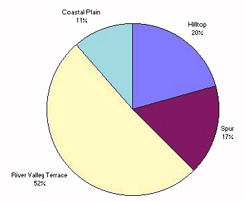
Fig. 6.33. Pie chart showing the topographical situation of all settlement
locations
When all the eighty-eight known sites are examined together, 51.13% are situated on river valley terraces, 20.45% on hilltops, 17.04% on spurs of land, and 11.38% on the coastal plain (Fig. 6.33). This indicates that a large proportion of settlements throughout the Iron Age and Roman period were located on the valley sides below the castros (Table 6.10).
| Situation | Previously known sites | Newly discovered sites | Total |
|---|---|---|---|
| Hilltop | 17 (42.5%) | 1 (2.08%) | 18 (20.45%) |
| Spur | 13 (32.5%) | 2 (4.17%) | 15 (17.04%) |
| River valley terrace | 5 (12.5%) | 40 (83.33%) | 45 (51.13%) |
| Coastal plain | 5 (12.5%) | 5 (10.41%) | 10 (11.36%) |
| Total | 40 | 48 | 88 |
One of the more significant conclusions to be drawn from these data is that there were a large number of Iron Age sites contemporary with the castros but not located in defensive situations. The twenty-seven newly discovered Iron Age sites are also generally in the same types of locations as the Roman sites, that is on the river terraces and coastal plain. This dimension of the archaeological record has not previously been systematically recorded.
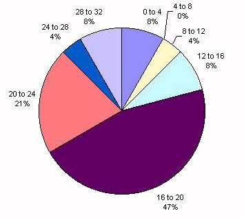
Fig. 6.34. Pie chart demonstrating the gradient of slope surrounding castros
Analysis of the immediate and surrounding slope gradients of the sites shows that, whilst the immediate gradient of all locations was shallow, a marked contrast between different settlement locations was evident. For castros, 80% have surrounding gradients of slope of between 16 and 32°, with the remaining 20% ranging between 0 and 16° (Fig. 6.34). However, Roman settlement locations show a marked difference, with 49% showing surrounding slope gradient of less than 8°, and all Roman sites being located on ground with surrounding gradient of slope of less than 20°.
| Immediate gradient of slope (degrees) |
Sites known prior to survey |
Newly discovered sites | Total |
|---|---|---|---|
| 0 to 4 | 30 | 35 | 65 |
| 4 to 8 | 7 | 12 | 19 |
| 8 to 12 | 2 | 1 | 3 |
| 12 to 16 | 1 | 0 | 1 |
| 16 to 20 | 0 | 0 | 0 |
| 20 to 24 | 0 | 0 | 0 |
| 24 to 28 | 0 | 0 | 0 |
| 28 to 32 | 0 | 0 | 0 |
| Total | 40 | 4 | 88 |
Comparison of immediate and surrounding gradient of slope in the vicinity of the newly discovered sites indicates that all are situated on flat or shallow sloping ground, surrounded by similar gradients of slope. Of these, 73% are located on ground with between 0 and 4° of slope, with 25% on ground of between 4 and 8° of slope. A slight difference in values is shown for the surrounding gradient, but 49% are surrounded by gradients of 0 to 4°, and 38% are surrounded by gradients of 4 to 8°. None of the sites is situated on, or surrounded by, slopes with a gradient greater than 12°.
Both these sets of patterns are again influenced by the nature of the datasets. The previous bias towards hilltop sites contrasts with the flatter agricultural land which characterised the fieldwalked areas.
| Surrounding gradient of slope (degrees) |
Sites known prior to survey |
Newly discovered sites | Total |
|---|---|---|---|
| 0 to 4 | 6 | 24 | 30 |
| 4 to 8 | 4 | 18 | 22 |
| 8 to 12 | 3 | 6 | 9 |
| 12 to 16 | 6 | 0 | 6 |
| 16 to 20 | 13 | 0 | 13 |
| 20 to 24 | 5 | 0 | 5 |
| 24 to 28 | 1 | 0 | 1 |
| 28 to 32 | 2 | 0 | 2 |
| Total | 40 | 48 | 88 |
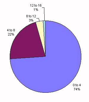
Fig. 6.35. Pie chart showing the gradient of slope in the immediate vicinity of
all settlement locations
An examination of the evidence from all known sites shows a similar pattern for the immediate gradients, with 74% located on ground of between 0 and 4° slope, and 22% on ground of between 4 and 8° (Fig. 6.35; Table 6.11). For surrounding gradient, a greater proportion of sites have a steeper gradients, with 34% positioned with 0 to 4° gradient, 35% between 4 and 12°, and 31% of between 12 and 32° (Fig. 6.36). This is because of the inclusion of castro locations in the calculations (Table 6.12).
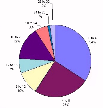
Fig. 6.36. Pie chart showing the gradient of slope surrounding all settlement
locations
These results, compared with those from the previous archaeological record, show that settlements are generally situated to take advantage of relatively flat locations. There was no need for steep surrounding gradients except at castros. Again, the existence of Iron Age sites away from the castros shows that defensive factors or symbolic visibility were not always important in determining settlement location in this period. The relationship between defensive and non-defensive Iron Age locations is addressed further in section 6.4.4.
Analysis of slope aspects used eight points of the compass for slope direction, based on a raster grid coverage of slope aspect in the GIS. Results did not indicate a particularly strong preference for settlement on ground sloping in any particular direction (Table 6.13). A large proportion of castros are in positions with multiple directions of slope, a product of their hilltop locations.
| Aspect of slope | Castros | Roman sites | Total |
|---|---|---|---|
| north | 1 | 0 | 1 |
| north-east | 0 | 1 | 1 |
| east | 0 | 3 | 3 |
| south-east | 1 | 0 | 1 |
| south-east | 1 | 0 | 1 |
| south-west | 0 | 4 | 4 |
| west | 0 | 6 | 6 |
| north-west | 1 | 1 | 2 |
| multiple | 20 | 1 | 21 |
| Total | 24 | 16 | 40 |
Of the newly discovered sites, 45% are located on ground with a south-western, southern or south-eastern aspect. However, a high proportion are located with north-easterly, northern or north-westerly aspects. No strong overall trend could be seen here or when all eighty-eight known sites are considered (Fig. 6.37). What is perhaps more important is not the site's aspect, but rather the distribution of settlements in relation to the south-east facing valley sides.
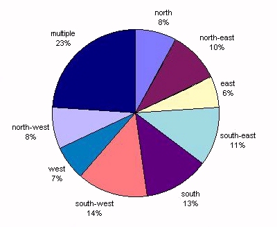
Fig. 6.37. Pie chart showing aspects of slope for all settlement locations
| Aspect of slope |
Sites known prior to the survey |
Newly discovered sites | Total |
|---|---|---|---|
| north | 2 | 5 | 7 |
| north-east | 3 | 6 | 9 |
| east | 0 | 5 | 5 |
| south-east | 1 | 9 | 10 |
| south | 5 | 6 | 11 |
| south-west | 6 | 6 | 12 |
| west | 1 | 5 | 6 |
| north-west | 2 | 5 | 7 |
| multiple | 20 | 1 | 21 |
| Total | 40 | 48 | 88 |
These trends of slope and aspect in settlement location are not purely a product of the regional topography. It would be easy to assume, for instance, that defended settlements generally had a higher altitude than other Iron Age or Roman sites. This is incorrect; slope is not necessarily related to altitude or elevation and, overall, no great change in settlement altitude occurs between phases. The location of sites in relation to slope and aspect probably reflects social and cultural choices. What is apparent is the importance of the topographical relationship between sites of different phases in individual localities.
© Internet Archaeology
URL: http://intarch.ac.uk/journal/issue9/millett/stats2.html
Last updated: Sat Dec 30 2000