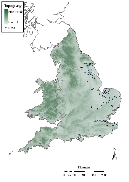
Figure 100: Clickable map of excavated and 'productive' sites included in Section 4.4
This section presents the individual fingerprints for each site, with a short account of what is known of the site, and any published references.

Figure 100: Clickable map of excavated and 'productive' sites included in Section 4.4
Of the 69 sites included in the VASLE 'Sites Dataset' (Fig. 100), fourteen are excavated sites: Beverley, Canterbury (Marlowe Street), Flixborough, Hartlepool, London (Royal Opera House), London (St Peter's Hill), Southampton (Hamwic), Sandtun, Thwing, Wharram Percy, Whitby Abbey, Whithorn, York (Coppergate) and York (Fishergate). A small number of sites – Bamburgh, Barham, Cottam A, Cottam B, and Cowlam – have been subject to some excavation, although the VASLE dataset is largely derived from metal-detected material. Two datasets – Meols and Reculver – are largely based on finds discovered as a result of coastal erosion.
The selection of metal-detected sites was largely based upon those sites for which records could be acquired and had significant numbers of finds, and which therefore could be categorised as 'productive sites'. A fixed definition of what constitutes a 'significant number' cannot be applied, as this varies regionally as something that stands out above the norm, but generally sites had to have at least 20 non-ferrous artefacts and/or coins to be included in the sample. The list is by no means comprehensive as the VASLE project targeted sites that featured in the PAS database, or which were accessible in the Norfolk or Suffolk HERs. Nonetheless it is generally representative of the spread of 'productive sites' across the country (see Section 4.1.1). Of the 55 metal-detected sites, 21 are from Norfolk, seven from East Yorkshire, six from Suffolk, six from Lincolnshire, four from Kent, three from North Yorkshire, two from Cambridgeshire, and one each from Bedfordshire, Cheshire, Essex, Northumberland, Sussex, and the Isle of Wight.
The following individual site reports follow a common format. Any published references are provided, and if there is a permanent URL for an English Heritage NMR Excavation Index record of any fieldwork or National Inventory record of the site this is also given. In most cases this will provide a link to the record held by the Archaeology Data Service, which also allows the user to plot the location of the site.
The text description commences with a brief account of the local context or topography, where known. Relevant known Anglo-Saxon archaeological features, early churches, documentary references, or early place-names are also described. Finally, any known information about the metal-detecting activity and Anglo-Saxon artefacts and coinage recovered is then recorded. In the case of the excavated sites a short summary of the excavation is provided. For each site, links are provided to the individual fingerprint charts.
© Internet Archaeology/Author(s)
URL: http://intarch.ac.uk/journal/issue25/2/4.4.html
Last updated: Tues Apr 21 2009